
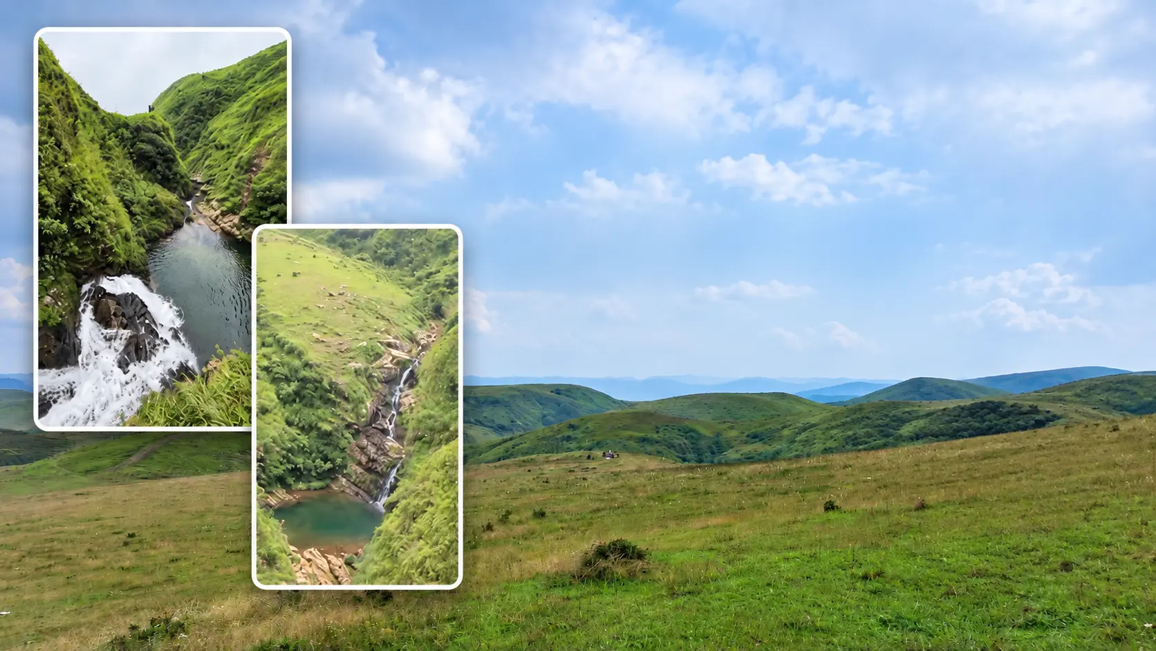
Photographs: Suman Samanta / Best of Northeast.
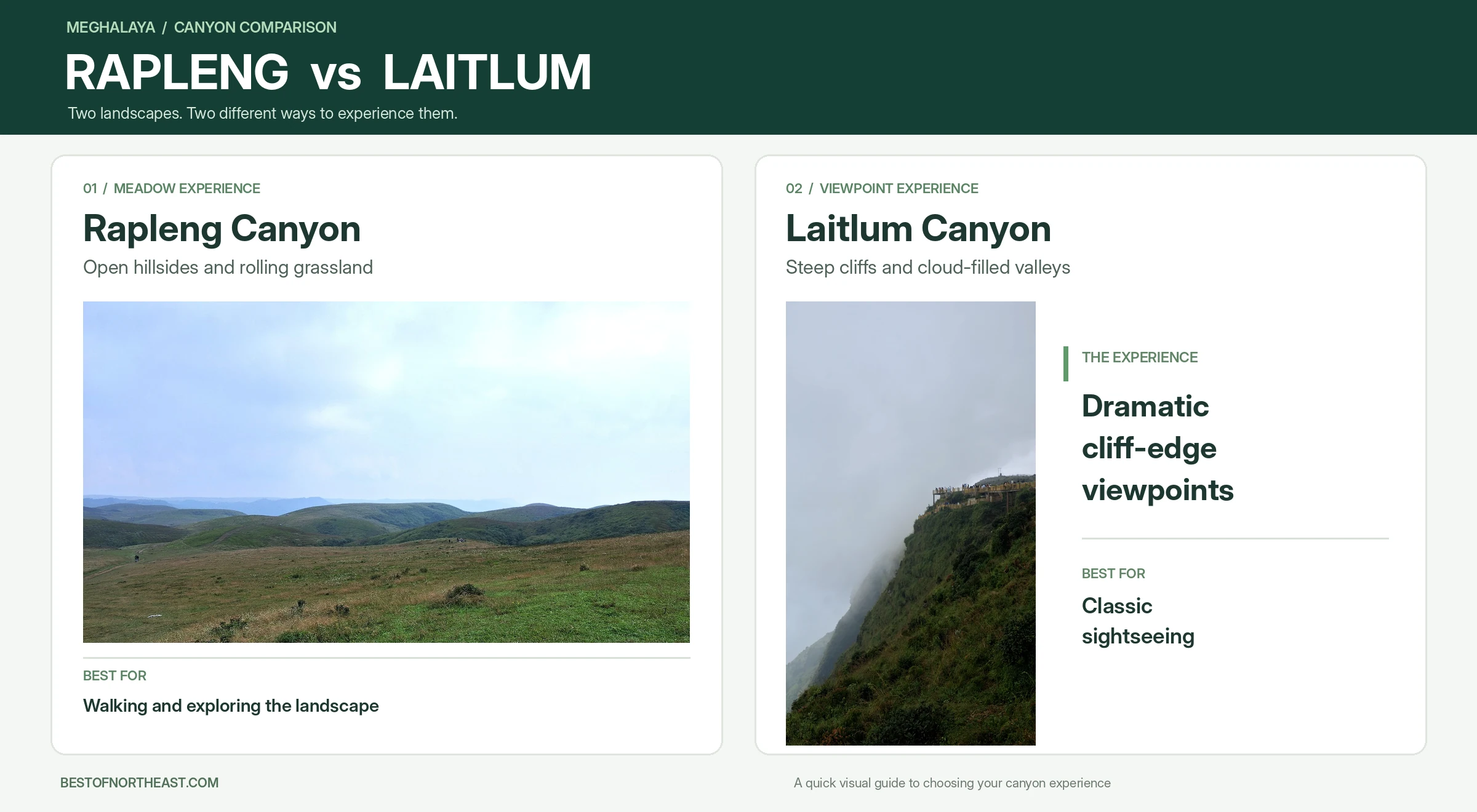
Rapleng Canyon vs Laitlum Canyon is a choice between two nearby experiences: the Rapleng roadside area is about a 5 km drive from Laitlum’s viewpoint. Choose Laitlum for a sweeping canyon panorama, or Rapleng for a longer walk through rolling meadows. Your time, the weather and how much walking you want to do will help you decide.
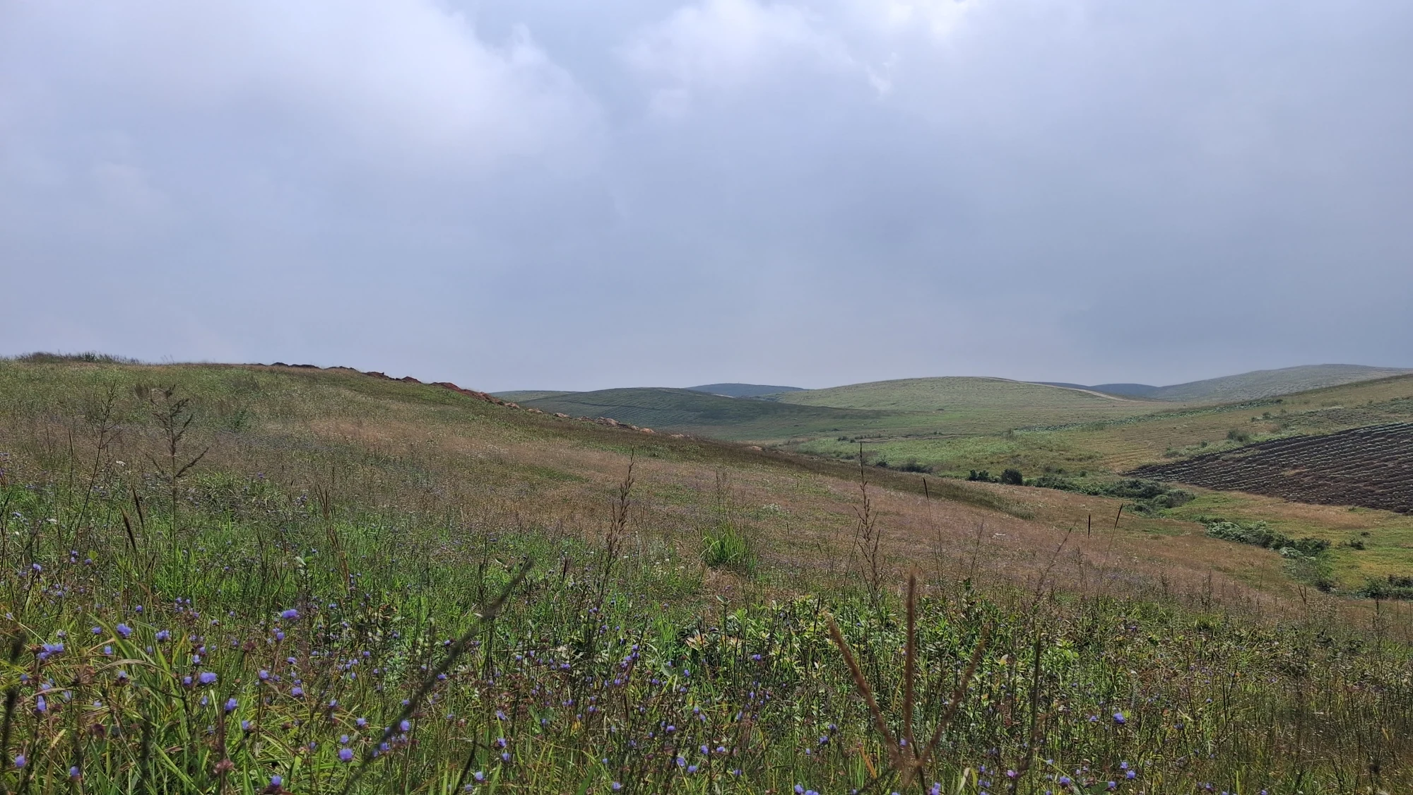
Both have grassy landscapes. Meghalaya Tourism describes Laitlum as a place of cliffs and meadows above deep valleys. During a recent visit, Best of Northeast publisher Suman Samanta explored Rapleng Canyon with his family, including two young children aged 1.5 and 3.5 years. The undulating meadow became the highlight, leading them toward a small, lake-like waterbody surrounded by meadow slopes and rocky formations.
Rapleng Canyon vs Laitlum Canyon at a glance
| If you want… | Better starting point | Why |
|---|---|---|
| A canyon panorama with a shorter outing in mind | Laitlum | Its viewpoints put the broad valley scenery at the centre of the visit. |
| Time to wander through a rolling landscape | Rapleng | The meadow walk includes repeated rises and dips on the way to a small, lake-like waterbody. |
| A longer, separate trek | Laitlum | Meghalaya Tourism lists a trek to Rai Um village, distinct from taking in the viewpoints. |
| An unhurried exploration with room to turn back | Rapleng | The meadow is part of the experience, even if you decide not to continue to the water. |
Laitlum also has meadows, and a Rapleng visit need not become a long hike. Give yourself the freedom to choose a comfortable stopping point.
Laitlum: wide views and a flexible visit
Laitlum is a good choice when your priority is a dramatic view without making the whole day about reaching it. The attraction is the contrast between the grassy high ground and the valleys below. Clouds and light can change the scene, so it is worth allowing time to look around rather than treating the viewpoint as a photograph stop alone.
The official tourism guide places Laitlum in East Khasi Hills, about 25 km from Shillong. It identifies Smit as the nearby village and says the drive from Smit to the canyon takes about 15 minutes. There is no direct local bus to Laitlum, according to the same guide, so arrange a taxi or day tour and agree on your return transport before leaving Shillong.
You can make the viewpoints the focus of the trip, or plan a longer outing separately. Meghalaya Tourism lists a trek to Rai Um village among the experiences here. A descent into the valley is a different commitment from enjoying the panorama above it, so discuss the route, return climb and current conditions with a knowledgeable local guide before setting out.
Choose Laitlum if: you want the familiar sweep of canyon scenery, have a limited window, or prefer to decide on the day how much walking to add.
Rapleng: the walk is part of the reward
Rapleng makes sense when you want to move through the landscape rather than look at it from a single point. The hills rise and fall in grassy folds, and the changes in terrain are part of what makes the visit memorable.
For Suman and his family, Rapleng was an unexpected discovery. After visiting Laitlum, they were driving toward Umkhoi Canyon and Kolington Lake, stopping along the way wherever the scenery caught their attention. At one stop they noticed a small roadside shop and parked cars nearby. The shopkeeper mentioned a waterfall, and a map search identified Rapleng Canyon Waterfall.
They parked and set off across the meadow. A returning couple looked exhausted but happy, and warned of repeated ups and downs with small children. They suggested walking a little more while comfortable, for the beautiful views. The family hesitated, then kept going with breaks, Suman carrying each child in turn when needed. Suddenly they came to a rocky, cliff-like formation and carefully made their way down toward a small, lake-like waterbody surrounded by curving meadow slopes and rock. It did not look like the waterfall they had imagined. Instead, the waterbody within that sweeping landscape was far more beautiful than they had expected.
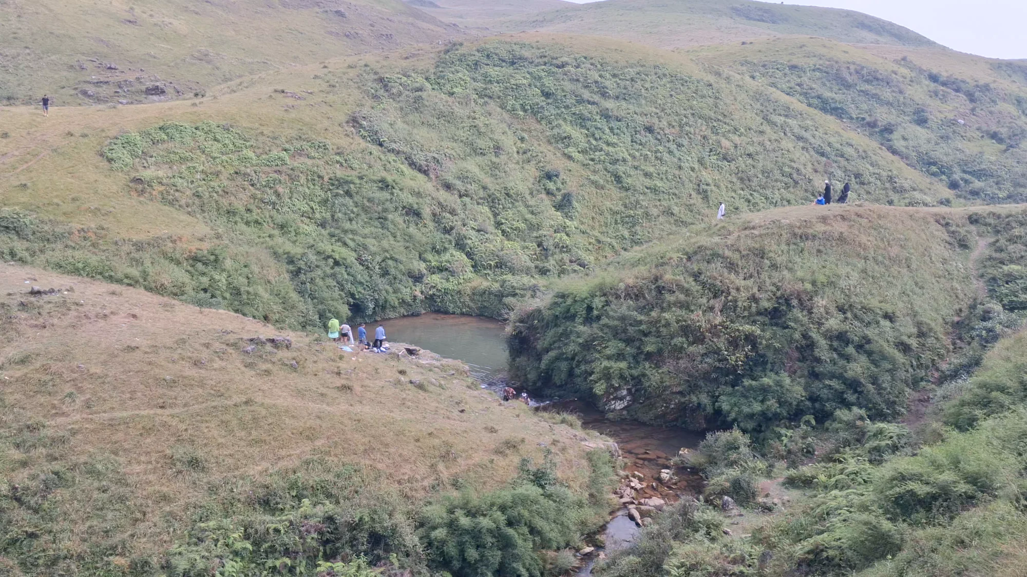
Suman recalls that he and his family spent around two hours there and left tired, but wishing they could stay longer. Allow a few hours for the outing, with breaks and the return, rather than treating it as a roadside stop. Set your own pace: walk, take photographs, stop for a snack on the grass and turn back when your group has had enough.
Choose Rapleng if: you enjoy an uneven walk, have time to pause, and are happy for the meadow and changing views to be the destination as much as the water.
Why Rapleng’s meadows can be overlooked
A waterfall pin can make the endpoint seem like the whole attraction. Suman and his family had not planned to stop at Rapleng; they discovered it after pausing for the scenery and asking at a roadside shop. Returning walkers then warned them about the effort of reaching the water. Someone who drives on, or judges the visit only by the waterfall, may miss the grassy folds and changing views along the approach. You can enjoy those without committing to the entire walk. Go for the landscape, with the water as one part of it.
How to find Rapleng and plan the walk
Finding Rapleng becomes easier once you understand that the roadside shop, parking area and waterbody are separate locations. Google Maps can be misleading if you navigate directly to the pin marked Rapleng Canyon Waterfall, because that pin does not identify where visitors should park or begin walking.
From Shillong, arrange a taxi or day tour via Smit to Laitlum, about 25 km away, then continue toward Rapleng. Google Maps shows a 4.6 km drive from Laitlum to Maxout Paramotoring, heading north and then right onto Jongksha-Mawkynrew Road. This is a useful road landmark, not the parking area or walking destination.
Where Suman’s family parked and started walking
During their visit, Suman’s family noticed a small roadside shop with vehicles parked nearby. The shopkeeper mentioned a waterfall, prompting them to check Google Maps and explore further.
Suman has since clarified the exact sequence of their visit:
- Roadside shop and parking fee: The family first stopped at the shop, where the parking fee was collected. This is the landmark visitors should look for before proceeding to the parking area.
- Parking area: After paying at the shop, they drove less than 50 metres farther to reach the designated open parking area, as indicated on the annotated map below. They left their vehicle here before beginning the walk.
- Walking trail: From the parking area, a visible trail leads across the rolling meadows, with repeated climbs and descents.
- Waterbody: The trail eventually approaches a small, lake-like body of water surrounded by rocky formations and grassy slopes. This was the family’s farthest destination, although it did not resemble the waterfall they had initially expected (visiting many high spectacular waterfalls in Maghalaya).
A useful navigation tip: Do not navigate directly to the existing Rapleng Canyon Waterfall pin expecting to reach the parking area. Instead, follow the parking location indicated below.
Useful Google Maps links:
- Rapleng Canyon Waterfall Parking & Toilet: https://maps.app.goo.gl/fK9GqBeXoK2iwbbZ9
- Roadside shop / fee collection point: https://maps.app.goo.gl/8zZsCL35fsdmNRnq8
- Rapleng Canyon Waterfall: https://maps.app.goo.gl/mSXefHT6CAPP6sKa7
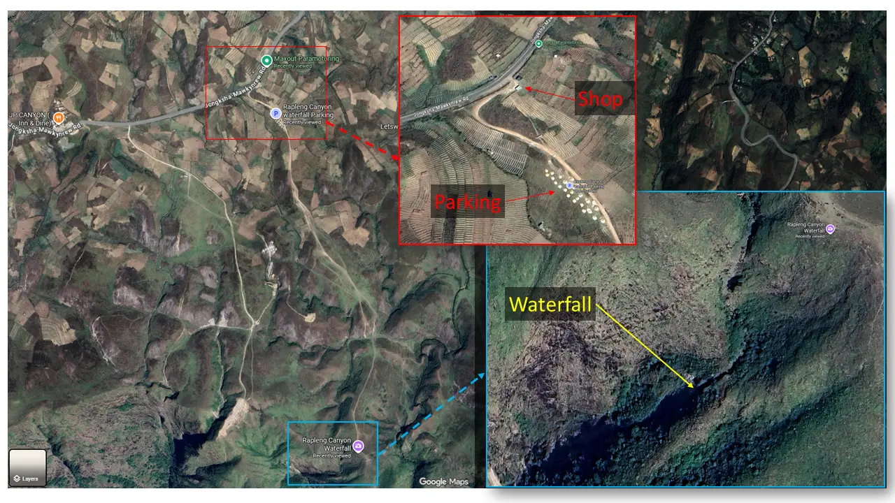
Where to pay, park and begin walking
Google Maps also lists Rapleng Canyon Waterfall (FW5J+2QG). Use it for orientation only: it does not show a footpath, and the farthest point the family reached was near the pin, not at it. Confirm the walking route locally before setting out.
Expect repeated climbs and descents, not a flat stroll. The family found the walk enjoyable but tiring. Their children needed carrying at times, especially uphill and near the waterbody. Downhill stretches were fun for them, but the return still needed energy. Take breaks and choose a turnaround point that suits your group. You can enjoy the meadows without reaching the waterbody.
Parking fees were collected at the roadside shop during Suman’s visit.
₹100. Travellers should confirm the current amount locally, as charges may change. Other facilities, marked-trail arrangements and camping permissions have not been independently verified.
Weather, footwear and what to carry
For Rapleng’s meadow walk, aim for October to February. Meghalaya Tourism calls winter (November to February) the driest season and, with the post-monsoon months, the best time to explore the state’s hinterland. Weather remains unpredictable, so check conditions after rain. The official Laitlum guide recommends October to May. Our Northeast monsoon travel guide covers planning in the wetter months.
Wear shoes with a good grip and bring drinking water. Suman also recommends food or snacks and a mat for sitting on the grass. For their next visit, the family plans to arrive in the morning with enough food and water to spend longer exploring. Arrange transport for the time you intend to stay, leave daylight for your return and take your rubbish back with you.
At the rocky water area, the family made their way down with great care. Meghalaya Tourism’s seasonal advice recommends viewing river attractions from a distance during the monsoon and says water activities are not permitted in most areas then.
Can you visit both in one day?
Yes, the two can fit into the same outing. The family visited Laitlum first and discovered Rapleng during their onward drive. The road landmark near their stop is about a 5 km drive from Laitlum; leave time for the walking as well. If you plan to explore Rapleng on foot, avoid filling the rest of the day so tightly that you have to rush the return or skip the landscape around you.
Start with Laitlum if the panorama is your main priority. Then continue toward Rapleng if you have enough daylight, suitable weather and energy for the walk. If the weather closes in or your group prefers a gentler day, enjoy one place fully and save the other for another visit.
The choice
Laitlum offers the immediate drama of a broad valley panorama, with the option to plan a longer trek separately. Rapleng rewards curiosity and time on foot: its grassy rises, the small waterbody tucked among them and changing views form one connected experience. Pick Laitlum for the view you came to see; pick Rapleng when the journey through the landscape is the part you most want to remember.
If your wider trip continues through Shillong toward Sohra, our Guwahati-to-Cherrapunji itinerary offers onward ideas. Explore our Meghalaya travel guides for more destinations.
About this guide: This article was researched and written by Blake Ahadi, incorporating firsthand observations and original photographs from Best of Northeast publisher Suman Samanta’s family visit to Rapleng Canyon.