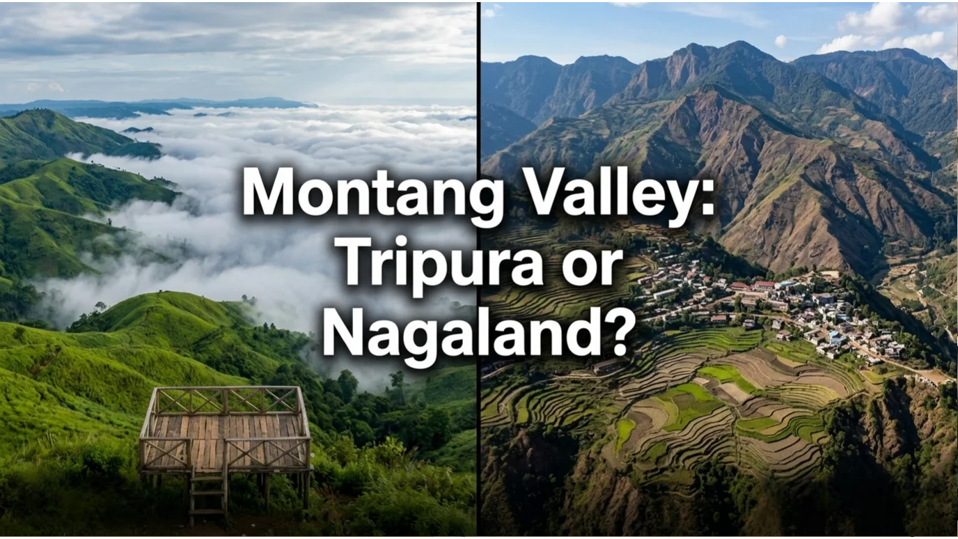
If you search for Montang Valley online, you’ll quickly run into confusion. Some sources place it in Tripura, while others point to Nagaland.
The truth? Both results come from real places – but only one is officially named Montang Valley. This guide explains the difference, where each location is, and which one you should actually visit in 2026.
Over the past year, photos of a place called Montang Valley have exploded across Instagram, YouTube Shorts, and Pinterest. Floating clouds draped over dramatic green hills. Mist rising from dense forests. Travelers calling it the “Mountain of Peace.”
It looks like a place straight out of a dream – which is exactly why it keeps going viral.
But when you start planning a visit, something strange happens.
Search “Montang Valley” and you’ll find two completely different sets of information. One points to Tripura – a developing eco‑spot 80 km from Agartala. The other points to Nagaland – high‑altitude viewpoints near the Myanmar border.
Same name. Two states. Very different realities.
This is not a mistake. It’s a classic case of user‑generated naming drift – and this 2026 guide is the first to clearly explain what’s going on.
We’ve spent months researching travel discussions, tourism announcements, and firsthand travel reports across Northeast India to put this guide together.
Quick Answer: Is Montang Valley in Tripura or Nagaland?
Short answer:
The officially named Montang Valley is in Tripura.
The location often called “Montang Valley” in Nagaland actually refers to the cloud viewpoints around Pfutsero in Phek district.
The Difference in One Quick Table
Before we dive into the story, here’s the fast answer for anyone who just wants to know which Montang is which.
| Factor | Montang Valley, Tripura (The Original) | Nagaland “Montang” (Informal Name) |
|---|---|---|
| Official name | Montang Valley | Pfutsero highlands / Phek district |
| Location | Atharamura Hills, Khowai district, Tripura | Phek district, Nagaland (near Myanmar border) |
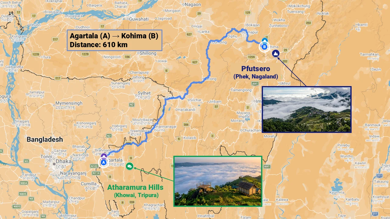
| Distance from capital | ~80 km from Agartala | ~200 km from Kohima |
| Elevation | Mid‑hill range (not specified) | 2,100+ metres (highest town in Nagaland) |
| Permits required | None for Indian citizens | ILP mandatory for Indians; PAP for foreigners |
| Road condition | Bumpy, narrow 30‑km track from NH‑8 | Poor – Pfutsero‑Zhavame stretch described as “horrible” |
| Facilities | 7‑8 local shops, 1 makeshift restaurant, basic homestays | Very limited community homestays |
| Best known for | “Floating clouds”, “Mountain of Peace” | High‑altitude cloud views, Chakhesang Naga culture |
| Travel difficulty | Moderate – doable as a weekend trip | High – requires permits, rough roads, more time |
Now let’s unpack why the confusion exists – and which one you should actually visit in 2026.
Table of Contents
How Social Media Created the Mix‑Up
This is the unique story no other travel site will tell you.
Step 1 – Tripura’s Montang Valley goes viral (2018–2022)
A journalist named Kamal Kalai discovered the valley in 2016, built a traditional bamboo hut, and shared photos. They spread like wildfire. Soon, #MontangValley and #MountainOfPeace were trending among Northeast Indian travel enthusiasts. The Tripura tourism department began promoting it as an “offbeat nature destination”.
Step 2 – Travelers visit Pfutsero, Nagaland
Pfutsero is the highest town in Nagaland (over 2,100 m). It also offers dramatic cloud‑covered viewpoints – very similar visuals to Tripura’s Montang.
Step 3 – The name jumps
Visitors to Pfutsero, not knowing an official name for those specific viewpoints, started using “Montang Valley” in their own social media posts. Location tags got messy. Hashtags mixed the two.
Step 4 – No authority steps in
No travel blog, no government website, no Wikipedia page published a clear disambiguation. The confusion grew unchecked.
Result in 2026: Google searches for “Montang Valley” return a jumble of results – some about Tripura, some about Nagaland, and many that don’t even realize there are two places.
This is your content gap. And this article fills it.
Why Everyone Is Suddenly Searching “Montang Valley” in 2026
Three forces are driving search demand right now:
- Social media discovery travel – Reels and Shorts show stunning visuals without location clarity. Viewers then search the name.
- Post‑pandemic Northeast boom – Domestic tourists are actively looking for “offbeat” and “less crowded” hill destinations.
- No clear authority – Because major travel sites haven’t locked the topic, confusion persists – and confused people search more.
The most common search queries we’re seeing in 2026:
- “Montang Valley Tripura or Nagaland”
- “Where is Montang Valley located”
- “Montang Valley which state”
- “How to reach Montang Valley”
All of these are signals of unsettled search intent – exactly the kind of gap that a well‑structured pillar article can own.
The Real Montang Valley in Tripura (The Original Destination)
Let’s start with the place that actually has “Montang Valley” as its official name.
Verified Facts
| Detail | Information |
|---|---|
| Official name | Montang Valley |
| Location | Atharamura Hills, Teliamura sub‑division, Khowai district, Tripura |
| Coordinates | 23°49′N 91°49′E |
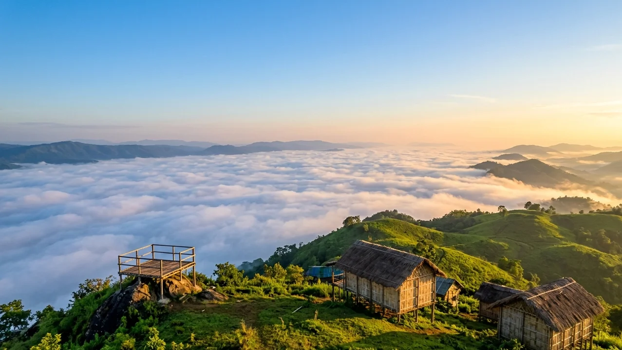
| Local nickname | “Mountain of Peace” |
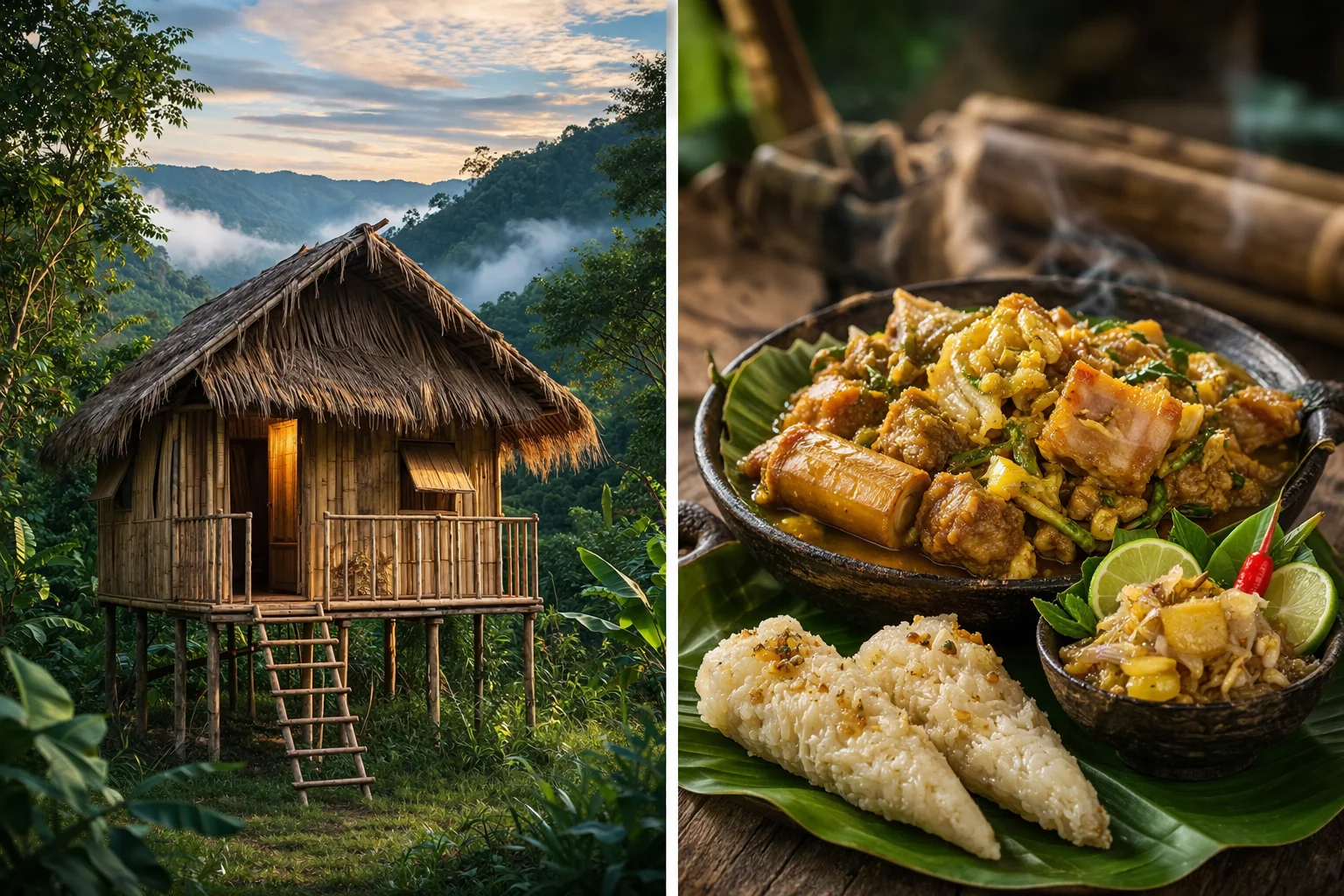
| Discovered by | Kamal Kalai (journalist, filmmaker, later TTAADC Executive Member) in 2016 |
| Distance from Agartala | ~80 km (~50 miles) |
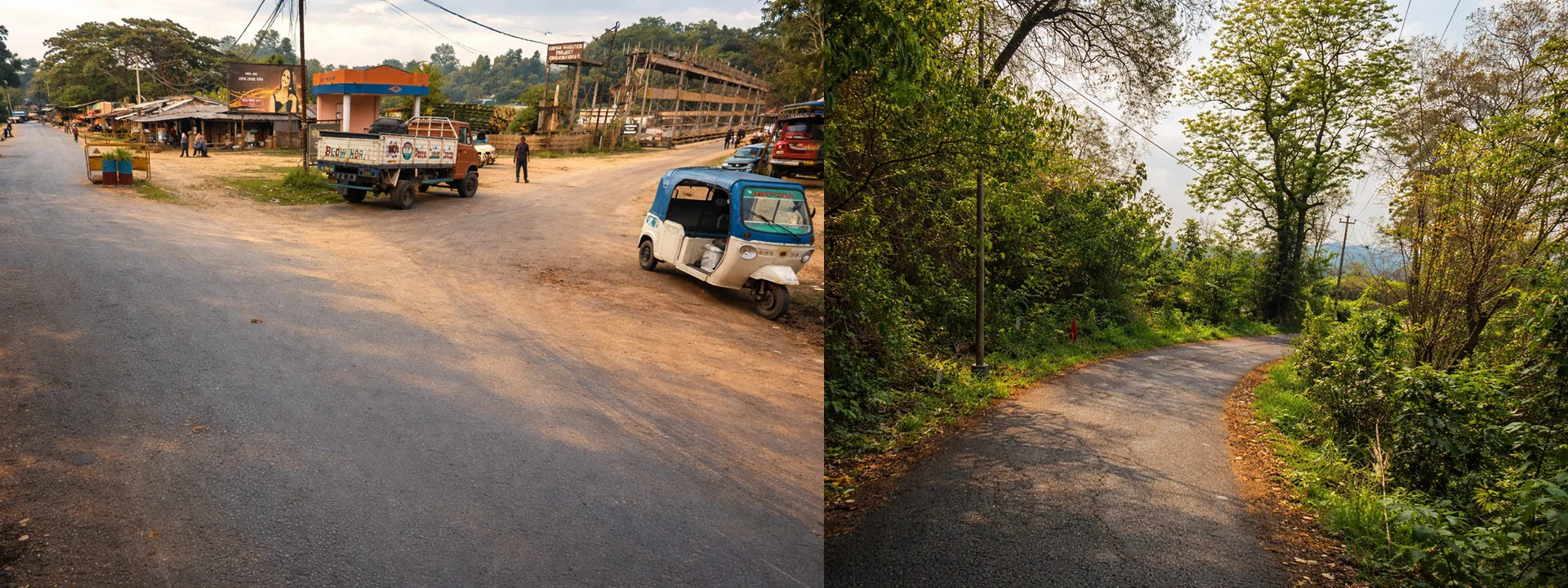
| Road connectivity | ~30 km winding track from NH‑8 near Chkmaghat barrage |
| Daily visitors (2026 estimate) | ~500 |
| Current facilities | 7‑8 local shops selling indigenous food & handicrafts, one makeshift restaurant (serves biryani, pork bharta, Bangoi), a few basic homestays, Kamal Kalai’s original “tong ghar” (bamboo hut) |
| Best time to visit | October–March (post‑monsoon for clear cloud views) |
What Makes It Special
The primary draw is the floating clouds – you stand at the viewpoint and watch clouds drift below you, creating a sea of white with hilltops poking through. It’s a genuinely beautiful, peaceful spot.
Unlike many viral destinations that fade quickly, Montang Valley in Tripura is steadily developing into a recognised eco‑tourism spot.
The local Tripuri community has embraced tourism. You can try Bangoi (rice boiled in special leaves) and pork bharta – simple, authentic, and cheap.
The Reality Check (Important for Honest Travelers)
- The road from NH‑8 to the top is bumpy and narrow. Not dangerous for a careful driver, but not comfortable either.
- Infrastructure remains basic. Don’t expect cafes, paved pathways, or luxury homestays.
- The Tripura tourism department has announced plans to widen the road and develop facilities – but as of early 2026, those are still plans.
- It is best visited as a day trip or overnight stay from Agartala.
How to Get There (Short Version)
From Agartala, take NH‑8 toward Teliamura. After ~50 km, turn off near the Chkmaghat barrage onto the 30‑km mountain track. Follow signs (or Google Maps – but download offline first). Total travel time: 3–4 hours one way.
A full detailed guide (“How to Reach Montang Valley from Agartala”) is coming soon as part of our Montang cluster.
The “Montang” Views of Nagaland (What Travelers Actually Mean)
Now let’s be clear: There is no officially named “Montang Valley” in Nagaland.
No Wikipedia page. No tourism department listing. No village or signboard with that name.
However, the landscapes travelers refer to are very real – and among the most dramatic high‑altitude viewpoints in the Northeast.
The Real Destination: Pfutsero & The Phek Highlands
Pfutsero is the highest town in Nagaland at over 2,100 metres (6,900 ft). It is located in the Phek district, near the Myanmar border. The area is known for:
- Dramatic cloud‑covered viewpoints – very similar visuals to Tripura’s Montang.
- Chakhesang Naga tribal culture – distinct festivals (Sökrönye in January, Tsükhenye in April), traditional morungs, and strong community identity.
- The “Vegetable Villages” – Razeba, Tsupfume, and Zelome, known for growing exotic produce like Yacon (ground apples).
Pfutsero lies beyond Kohima, which is often included in longer Northeast road trips like this Kamakhya to Kohima cultural journey.
Why Travelers Call It “Montang”
Simple: visual similarity + naming drift.
A traveler sees a reel of clouds over Pfutsero. They’ve heard of “Montang Valley” from Tripura’s viral posts. They assume the name applies to any cloud‑viewpoint in the Northeast. They tag it #MontangValley. Others copy.
No authoritative source has corrected this – until now.
The Reality Check for Nagaland
Visiting the Pfutsero highlands is not a casual weekend trip. You need:
- Inner Line Permit (ILP) for Indian citizens (apply online via eILP portal, specify Phek district)
- Protected Area Permit (PAP) for foreign nationals (must go through a registered tour operator, travel in groups of at least two)
- Significant travel time – Dimapur → Kohima → Phek → Pfutsero, with poor road conditions (the Pfutsero‑Zhavame stretch is often described as “horrible”)
- Limited accommodation – community homestays only, very basic
This is for serious explorers, not casual tourists.
Which One Should You Visit? (Decision Framework)
Use this simple decision tree.
| Your travel style | Choose |
|---|---|
| You want a weekend getaway from Agartala, Guwahati, or Silchar. | Tripura Montang Valley |
| You have no interest in permits or complex bureaucracy. | Tripura Montang Valley |
| You want floating cloud views without extreme logistics. | Tripura Montang Valley |
| You are an experienced Northeast traveler who has already done Meghalaya, Tawang, and Dzukou Valley. | Nagaland (Pfutsero) |
| You are specifically interested in Chakhesang Naga culture and festivals. | Nagaland (Pfutsero) |
| You are a foreign national – the PAP process for Nagaland is lengthy. For a first visit to the Northeast, Tripura is far easier. | Tripura Montang Valley |
Bottom line for 2026:
Which Montang Valley- Tripura or Nagaland?
For 90% of travelers, Tripura’s Montang Valley is the right choice. It’s real, accessible, and delivers the cloud‑view experience you saw on social media. Save the Nagaland highlands for a future, more advanced trip.
If you’re travelling independently, especially as a woman, you may also want to read our complete solo female travel guide to Northeast India before planning a Nagaland trip.
How to Reach Each Destination (Short Version – Full Guides Coming)
Tripura Montang Valley (Summary)
- Nearest airport: Agartala (IXA) – connected to Kolkata, Delhi, Guwahati.
- Nearest railway station: Agartala (daily trains from Lumding, Guwahati).
- By road from Agartala: ~80 km, 3–4 hours via NH‑8 + 30‑km mountain track.
- Best vehicle: Small SUV (higher clearance recommended).
Nagaland “Montang” (Pfutsero) (Summary)
- Nearest airport: Dimapur (DMU) – connected to Kolkata, Guwahati.
- Nearest railway station: Dimapur.
- By road: Dimapur → Kohima (~75 km, 2–3 hours), then Kohima → Phek → Pfutsero (~120 km, 5–6 hours on poor roads).
- Permits: ILP (Indians) or PAP (foreigners) must be secured before travel.
FAQ: Montang Valley Confusion
Is Montang Valley in Tripura or Nagaland?
The officially named Montang Valley is in Tripura. The Nagaland location refers to cloud viewpoints near Pfutsero that travelers informally call Montang Valley.
Why do Google results show Nagaland for Montang Valley?
Because travelers began using the name on social media for Pfutsero viewpoints, creating a mix of search results.
Do you need a permit to visit Montang Valley?
– Tripura Montang Valley: No permit required for Indian citizens.
– Nagaland Pfutsero region: ILP required for Indians, PAP for foreigners.
Which Montang Valley is better to visit?
For most travelers, Tripura is easier and more accessible. Nagaland is better suited for experienced Northeast travelers.
What is the best time to visit Tripura’s Montang Valley?
October to March, after the monsoon, when the skies are clear and the “floating clouds” are most visible.
Are there homestays at Montang Valley, Tripura?
Yes, a few basic homestays are available. More detailed accommodation information will be covered in our upcoming Montang Valley homestay guide.
What We’re Publishing Next (Montang Content Cluster)
This article is the pillar – the clarification authority that resolves the confusion. Over the coming weeks, we will publish the following deep‑dive guides:
| Order | Article | Purpose |
|---|---|---|
| 1 | Montang Valley Tripura Complete Travel Guide (2026) | Full destination guide – itineraries, costs, homestays, photography tips |
| 2 | How to Reach Montang Valley from Agartala (Road, Taxi, Self‑Drive) | Detailed logistics – exact route, road conditions, vehicle recommendations |
| 3 | Montang Valley Homestays & Facilities: 2026 Update | Honest review of current accommodation, food, and infrastructure |
| 4 | Pfutsero Highlands Guide: The Nagaland Cloud Viewpoints | Advanced guide for serious explorers – permits, culture, festivals, road conditions |
Each guide will link back to this pillar article, and this pillar article will point forward to those guides. That’s how we build topical authority – covering the topic from confusion to planning to execution.
Final Takeaway for 2026
The internet may still be confused about Montang Valley – but you don’t have to be.
If you want an accessible cloud‑view destination you can actually visit this year, head to Tripura.
If you’re planning a deeper expedition into Nagaland’s tribal highlands, save Pfutsero for a more advanced Northeast journey.
Either way, you now know what most travelers don’t.
Have questions? Still confused about which Montang is which? Drop a comment below – we reply to every query.
Last updated: March 2026. We review road conditions and permit rules every quarter. Check back for the latest.