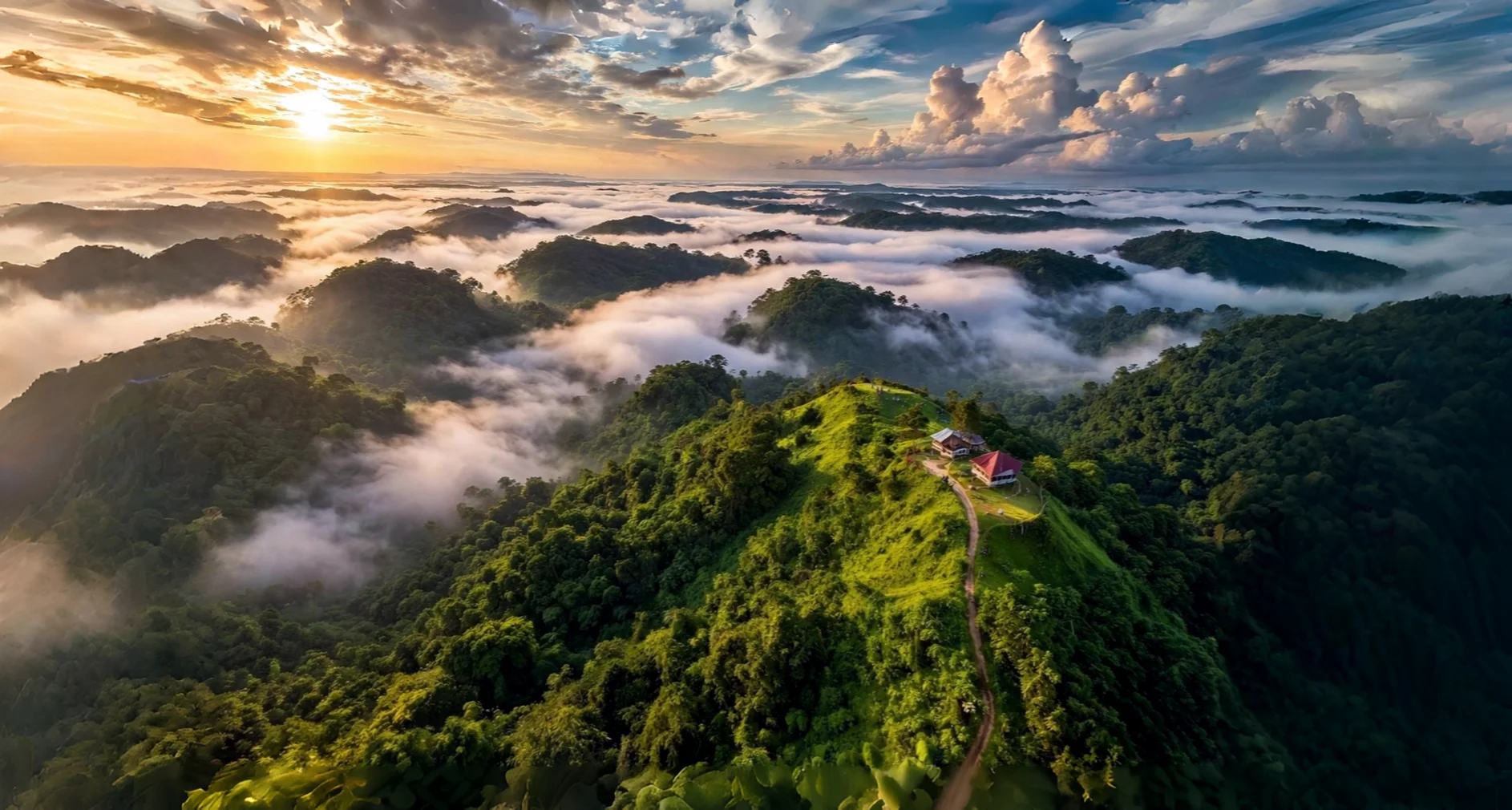
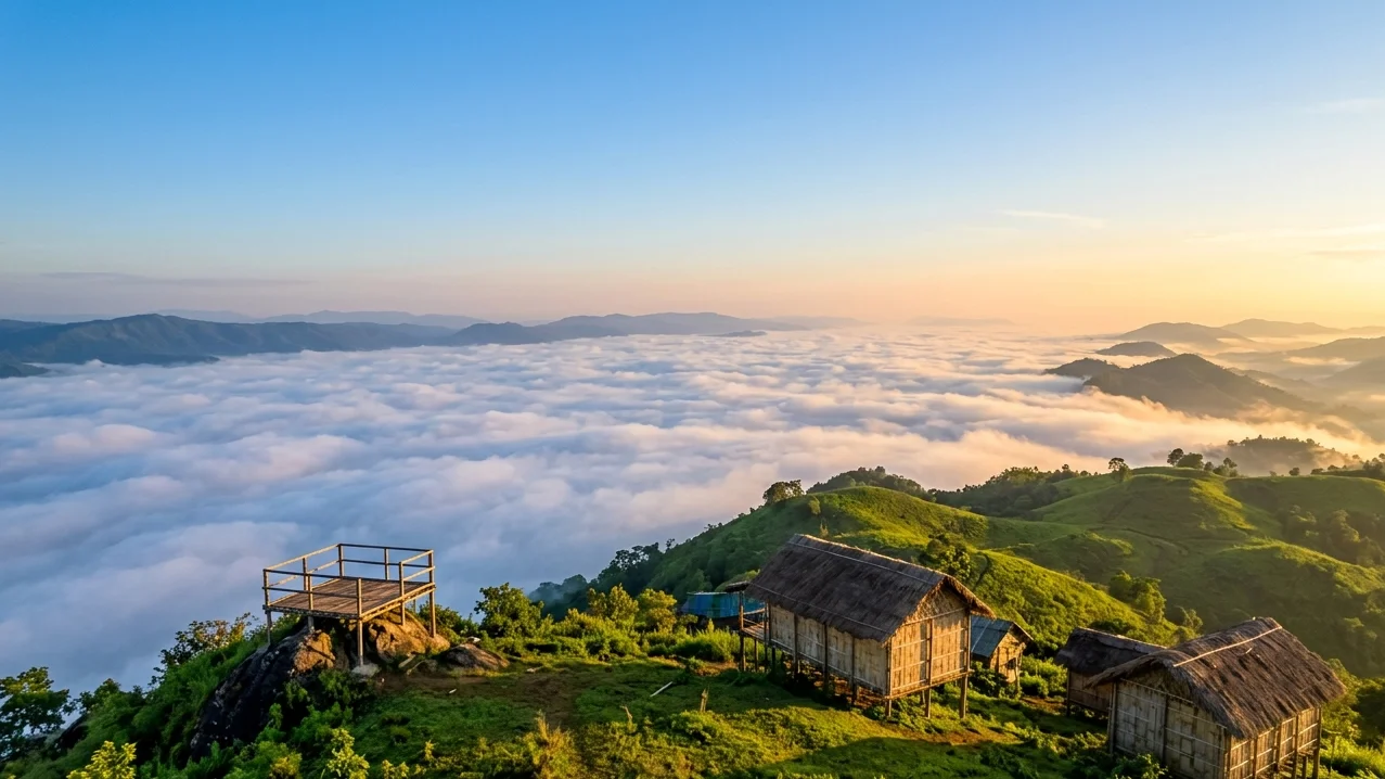
The “Mountain of Peace” in Tripura’s Atharamura hills has exploded on social media – but what’s the real story behind the floating clouds?
This is not a promotional piece. It’s a field‑tested, truth‑first guide to help you decide if Montang Valley belongs on your Northeast India itinerary.
We’ve spent months digging into official documents, visitor reviews, and the complex local land dispute that no other travel site mentions. Here’s everything you need to know to plan your visit in 2026.
Table of Contents
Where Is Montang Valley? (Location & Geography)
Montang Valley sits in the Atharamura hill range of the Khowai district, Tripura. The Atharamura range is part of the Indo‑Burma biodiversity hotspot, one of the most biologically rich regions on earth.
| Detail | Information |
|---|---|
| Official name | Montang Valley |
| Local nickname | “Mountain of Peace” (by Tripuri communities) |
| Coordinates | 23°49′N 91°49′E |
| Distance from Agartala | ~80 km (3–4 hours) |
| Nearest town | Teliamura (~30 km from the summit) |
The valley is a high‑altitude plateau that offers panoramic views of the surrounding hills and the Khowai river basin. Because of its elevation, it forms a micro‑climatic refuge – cooler and less humid than the Tripura plains – which is why the famous “floating clouds” occur so predictably in the early morning.
The Story Behind Montang’s Viral Rise
Montang didn’t become famous because of a government campaign. Its story is tied to one man: Kamal Kalai.
- 2016 – Kalai, a journalist and documentary filmmaker, first explored the area.
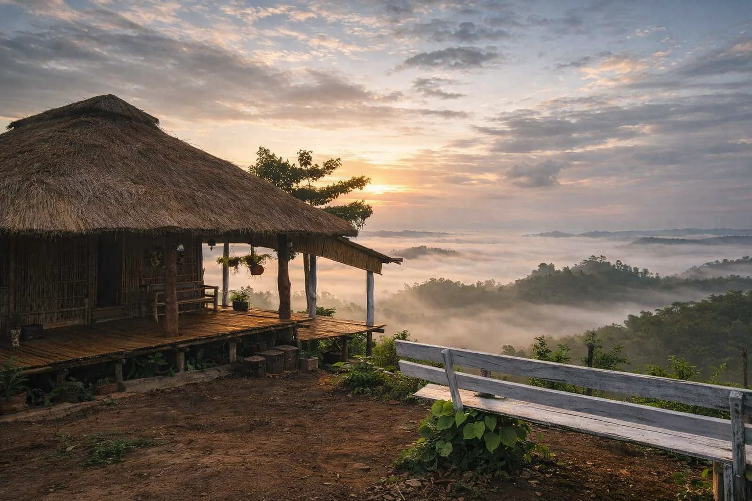
- He built a traditional “tong ghar” (a bamboo hut on stilts) as a personal retreat.
- In 2021, after being elected as an executive member of the Tripura Tribal Areas Autonomous District Council (TTAADC), he shared photos of the spot. The images went viral.
- The sudden rush of visitors forced the local administration to build a connecting road using PMGSY funds (Pradhan Mantri Gram Sadak Yojana).
Today, Montang attracts ~500 visitors daily, making it one of Tripura’s most popular offbeat destinations – yet infrastructure has barely kept pace.
Best Time to Visit Montang Valley (Cloud Science Included)
The “floating clouds” are a product of temperature inversion layers that form when moist air from the Bay of Bengal is trapped beneath cooler air in the valley. Timing your visit is everything.
✅ October – February: The Golden Window
- Why: Clear skies, low humidity, and the most reliable cloud displays.
- Morning temperature: 12–15°C – pack a jacket.
- Pro tip: Arrive at the summit by 5:30 AM to catch the sea of clouds before it dissipates.
⚠️ March – May: Summer – Possible but Sweaty
- Why: Days are hot (up to 35°C in the plains), but the valley stays 2–3° cooler.
- What to expect: Fewer clouds, more haze. Still doable if you’re on a tight schedule.
❌ June – September: Monsoon – Avoid Unless You’re an Adventurer
- Why: Heavy rainfall, landslides, and road closures are common.
- The road becomes dangerously slippery; even SUVs struggle.
- The only upside: waterfalls in the Baramura range are at their fullest.
| Month | Max Temp (°C) | Min Temp (°C) | Rainfall (mm) | Cloud View Quality |
|---|---|---|---|---|
| Oct | 30 | 21 | 169 | Excellent |
| Nov | 28 | 16 | 41 | Excellent |
| Dec | 25 | 13 | 5 | Excellent |
| Jan | 25 | 12 | 3 | Excellent |
| Feb | 29 | 14 | 13 | Good |
| Mar | 33 | 19 | 31 | Moderate |
How to Reach Montang Valley (Step‑by‑Step)
1. By Air (Most Convenient)
Fly to Agartala’s Maharaja Bir Bikram Airport (IXA). Regular flights from Kolkata, Delhi, Guwahati, and Bengaluru.
From the airport, you’ll need to arrange a private vehicle (more on that below).
2. By Train (Cheaper & Closer)
The nearest railway station is Teliamura (TLMR) , about 30 km from the Montang road turnoff. Several trains connect Teliamura to Guwahati and beyond:
| Train No. | Name | From Guwahati (GHY) | Arrival at TLMR | Days |
|---|---|---|---|---|
| 20502 | Agtl Tejas Rajdhani | 03:25 | 14:33 | Friday |
| 12503 | Agtl Humsafar | 12:55 | 00:40 | Sunday |
| 15650 | Nnge Agtl Exp | 17:00 | 05:22 | Daily |
| 01665 | Rkmp Agtl Spl | 03:35 | 17:10 | Saturday |
If you can’t get a train to Teliamura, Agartala station is also well‑connected – but you’ll add an extra 80 km of driving.
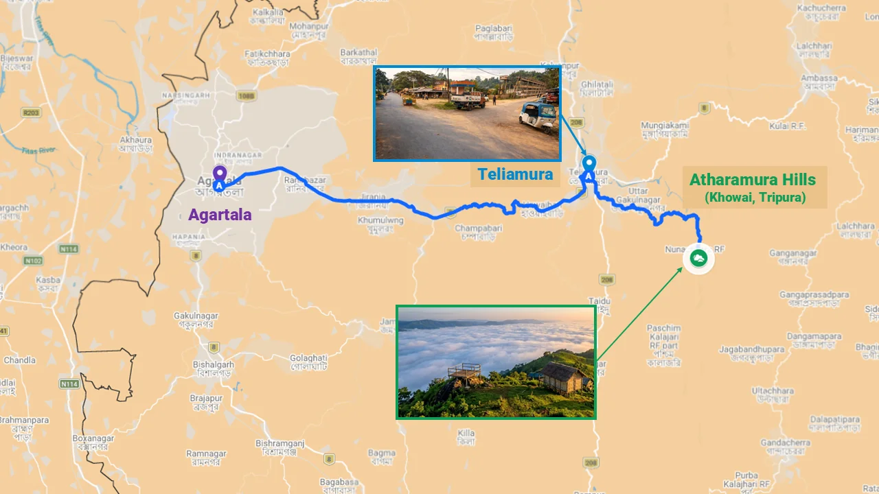
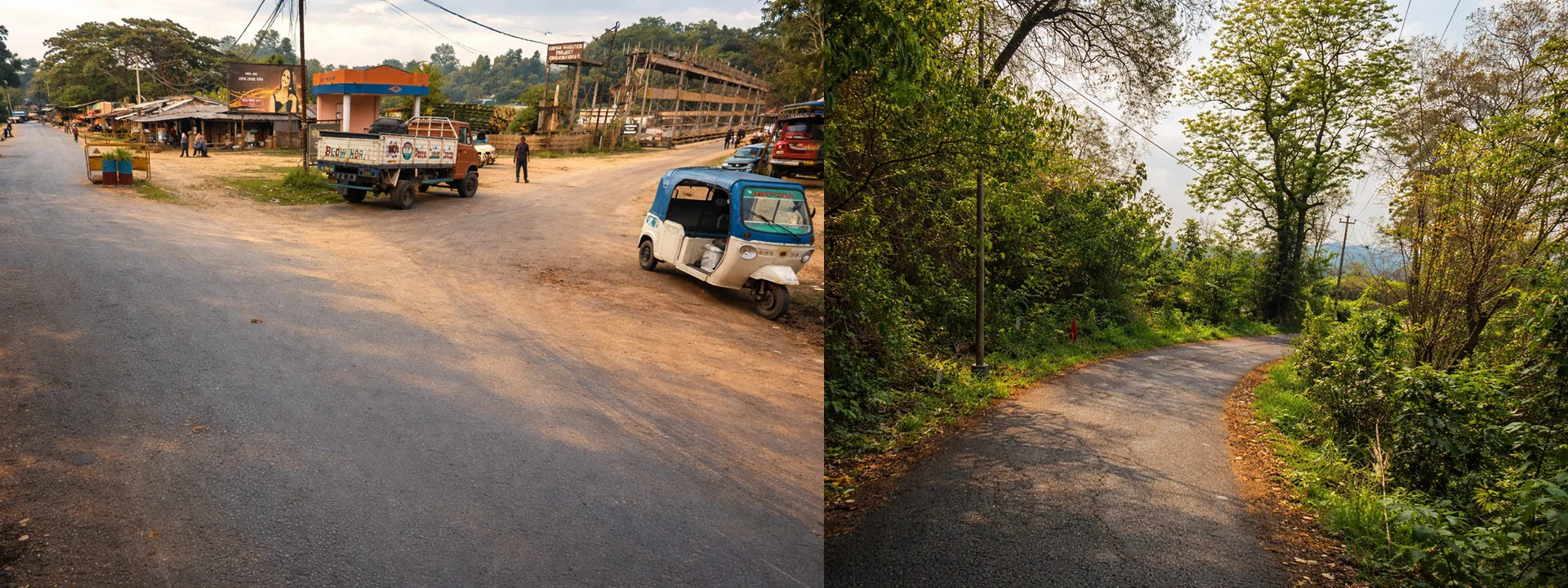
3. The Final 30 km: From Teliamura to the Summit
From Teliamura town, take NH‑8 towards the Chkmaghat barrage. Cross the Khowai river bridge, then take a sharp right onto the mountain track. This stretch is:
- 17–30 km long (sources vary)
- Paved but narrow – barely wide enough for two small cars
- Serpentine – steep turns, and sections that are bumpy
Important: There is no public bus or shared taxi for this last leg. You must reserve a private vehicle in advance (preferably an SUV with good ground clearance). Ask your hotel in Agartala or Teliamura to arrange one.
The Road Reality (Honest Section)
Let’s be blunt: the road to Montang is the biggest challenge.
Visitor after visitor complains about the “bumpy, narrow serpentine track” that “no visitor will like.” In 2026, local residents of adjoining villages continue to report that the road is “broken and nearly impossible during monsoons.” Children struggle to reach school, and patients face dangerous delays in medical emergencies.
The irony? While the road to the main viewpoint was built with central government funds (PMGSY), the surrounding villages remain neglected. As one local put it: “Montang gets all the attention, but we can’t even get our vegetables to market.”
What this means for you:
- Budget extra time (3–4 hours from Agartala is realistic, but add a buffer).
- Do NOT attempt in a low‑sedan car – especially after rain.
- Carry snacks and water – if you get stuck in a jam, there’s no roadside help.
Facilities & Accommodation Reality
Despite 500 daily visitors, Montang has no formal tourist infrastructure.
| Facility | Current Status |
|---|---|
| Shops | 7–8 small stalls selling local snacks, tea, and a few handicrafts |
| Restaurant | One makeshift eatery – serves biryani, pork bharta, and Bangoi |
| Accommodation | None – no tourist bungalow, no hotel. Kamal Kalai’s original “tong ghar” exists but is not a commercial guesthouse. |
| Water | Scarce – visitors have reported being charged up to ₹25 for a 500 ml bottle. Bring your own. |
| Toilets | Basic, if any – plan accordingly. |
We are currently researching homestays in the nearby villages and will publish a dedicated Montang Valley Homestays Guide soon. Until then, treat Montang as a day trip from Agartala or Teliamura.
Land Dispute & What It Means for Visitors (The Trust Section)
This is the part no other travel blog will tell you.
Since 2024, the Forest Department has been trying to reclaim the land where the main viewpoint sits, claiming that at least five families are illegal occupants. In January 2024, tensions escalated to a standoff involving police and CRPF.
The result for visitors:
- No standardized entry fee – pricing is decided informally by local families.
- Irregular costs – parking fees vary, water bottles are marked up, and there’s no official ticket.
- Development stalled – the state tourism department wants to build proper facilities, but the land dispute blocks funding.
Does this make Montang unsafe? No – the situation is monitored, and no violence has occurred against tourists. But it explains why infrastructure remains “very poor” despite the destination’s popularity.
What you should do:
- Carry small cash (₹100–500 notes) to cover parking and entry – expect to be asked for money.
- Don’t argue over prices – it’s not worth the hassle.
- If you encounter a tense situation, remain calm and leave if necessary.
What to See & Do at Montang Valley
1. The Floating Clouds at Dawn (Main Event)
- Where: The main viewpoint near the tong ghar.
- When: 5:30 AM – 7:00 AM (clouds usually burn off by mid‑morning).
- Pro tip: Arrive before sunrise to watch the valley fill with mist – it’s a photographer’s dream.
2. Banyan Tree Viewpoint
A short walk from the main area, this spot is free to enter and offers a wide‑angle view of the Atharamura range. It’s also less crowded, especially on weekdays.
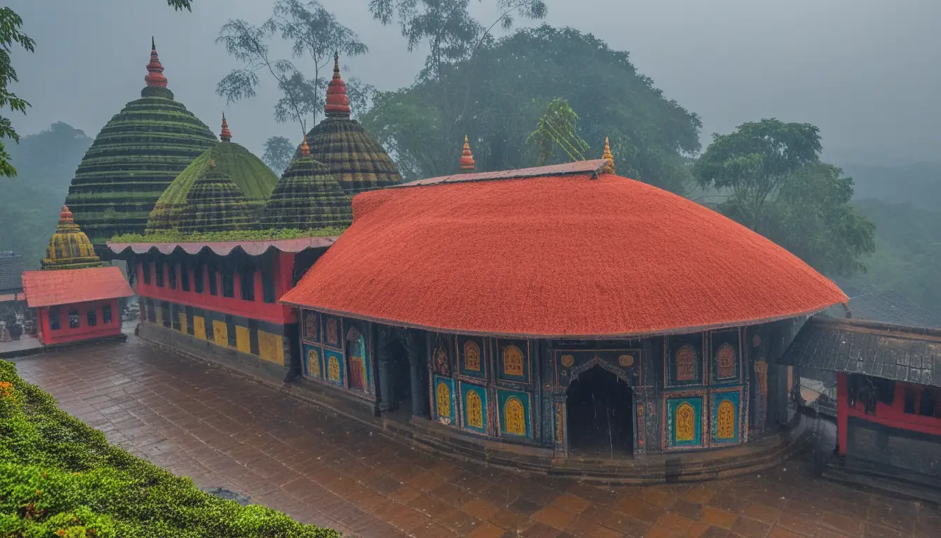
3. Tong Ghar (The Bamboo Hut)
Kamal Kalai’s original bamboo structure is now an unofficial landmark. You can’t stay overnight, but it’s worth seeing the traditional Tripuri architecture (elevated on stilts, built entirely from bamboo and cane).
4. Biodiversity Trails
The surrounding forests are home to primates, rare orchids, and birds. If you’re a nature enthusiast, spend an hour walking the unpaved trails (ask locals for directions – and always take a guide).
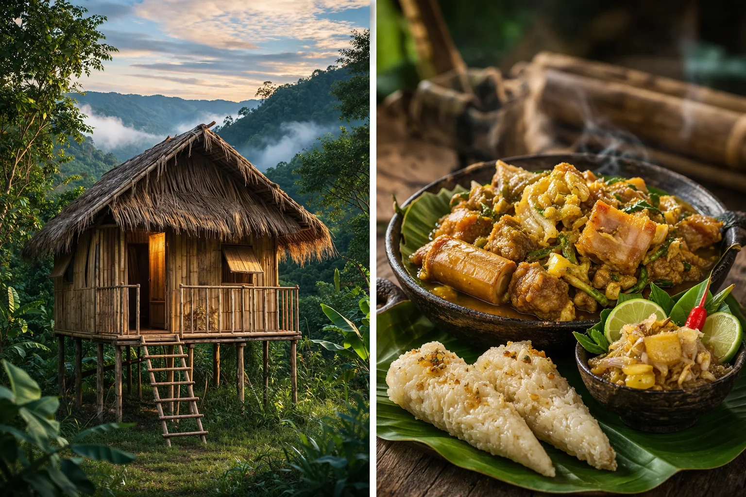
Food at Montang Valley: Tripuri Cuisine
The food is one of the most authentic reasons to visit. You won’t find fancy cafes, but the local stalls serve genuine Tripuri tribal dishes.
| Dish | Description |
|---|---|
| Bangoi | Special sticky rice boiled inside fragrant forest leaves – mild, aromatic, and filling |
| Wahan Mosdeng | A spicy pork “bharta” or salad with roasted chilies and ginger – often paired with Berma (fermented dried fish) for an umami punch |
| Gudok / Godok | Vegetables steamed with Berma inside bamboo pipes – a smoky, earthy flavour |
| Chuak | Traditional rice beer (fermented rice in water) – try it if offered, but it’s potent |
Insider tip: The makeshift restaurant (the only one) runs out of food by mid‑afternoon. Go early if you want a hot meal. Otherwise, the stalls sell snacks like pakoras and tea.
Cultural Etiquette & Safety
Etiquette for Visiting Tribal Areas
- Photography: Always ask permission before taking photos of people. Avoid using terms like “primitive” or “exotic” – it’s disrespectful.
- Dress: Modest clothing is appreciated, especially when visiting nearby temples or villages.
- Waste: There’s no formal garbage collection. Carry all non‑biodegradable waste back with you.
Safety Precautions
- No night travel: Roads are unlit, and mobile networks are patchy. Plan to be back in Agartala or Teliamura by sunset.
- Medical emergencies: The nearest quality hospital is IGM Hospital in Agartala. If you’re injured, a private vehicle will get you there faster than an ambulance.
- Crime rate: Tripura’s overall crime rate fell 8.3% in 2025, and the Khowai district is generally safe. Use standard precautions like locking your vehicle and not flashing valuables.
Sample Itineraries
Option A: Day Trip from Agartala (Most Common)
| Time | Activity |
|---|---|
| 4:00 AM | Depart Agartala in a reserved SUV |
| 5:30 AM | Arrive at Montang summit – catch the floating clouds at the main viewpoint |
| 7:00 AM | Breakfast at a local stall (Bangoi + tea) |
| 8:00 AM | Visit Banyan Tree Viewpoint, explore the area |
| 9:30 AM | Start descent (the road gets busier later) |
| 11:00 AM | Stop at Baramura Park for a short nature walk (optional) |
| 12:30 PM | Return to Agartala |
Cost estimate: Vehicle rental ₹2,500–₹4,000; food & incidentals ₹500–₹1,000.
Option B: 3‑Day Tripura Circuit (Montang + Heritage)
| Day | Location | Highlights |
|---|---|---|
| Day 1 | Agartala | Ujjayanta Palace, State Museum, local markets – overnight Agartala |
| Day 2 | Montang Valley | Dawn visit to Montang; on the way back, stop at Baramura Park – overnight Teliamura (limited options) or return to Agartala |
| Day 3 | Neermahal | Morning at Neermahal (lake palace), then depart |
Note: For a deeper cultural experience, consider combining with our guide to Nagaland’s Pfutsero highlands – another “Montang‑like” destination with a completely different tribal culture. (Read the confusion article first.)
Visitor Sentiment: What Travelers Actually Say
We analyzed dozens of reviews and local discussions to give you a balanced view.
Exceptional Experiences
- “Unseen Tripura – a hidden paradise with spectacular views.” – Photography enthusiast
- “The hospitality of the locals, even with the language barrier, was heartwarming.”
- “The pork bharta and Bangoi are worth the trip alone.”
Negative Trends
- “Bumpy road – no visitor will like it.” – Common refrain
- “₹25 for a 500 ml water bottle? No proper restaurant.”
- “On weekends it’s a mad rush – the peace is gone.”
- “No stay option. We had to rush back.”
Essential Packing List
| Item | Why |
|---|---|
| Cash (₹500–₹1,000 in small notes) | No ATMs; shops and “entry fees” are cash‑only |
| Drinking water & snacks | Limited availability; prices are inflated |
| Power bank | No charging points at the summit |
| Warm layer (Oct–Feb) | Early mornings are chilly at altitude |
| Rain gear (monsoon) | Sudden showers are common |
| Offline maps | Mobile network is patchy once you leave NH‑8 |
FAQ: Montang Valley, Tripura Travel Guide
Is Montang Valley in Tripura or Nagaland?
The officially named Montang Valley is in Tripura. The Nagaland “Montang” refers to cloud viewpoints near Pfutsero. Read our confusion‑clarifying pillar article for the full story.
Do I need a permit to visit Montang Valley?
No permit is required for Indian citizens. Foreign nationals should register at the airport on arrival but do not need a special permit for this location.
What’s the best time to see the floating clouds?
October to February, arriving at the summit by 5:30 AM. The phenomenon is most reliable during these months.
Is the road really that bad?
Yes – it’s a narrow, winding, and often bumpy track. An SUV is highly recommended, and you should avoid traveling after heavy rain.
Can I stay overnight at Montang?
Currently, no. There is no tourist accommodation. The nearest decent hotels are in Agartala or Teliamura (very basic). We’ll publish a homestays guide if conditions change.
Is it safe for solo female travelers?
Tripura is generally safe, but we recommend taking the same precautions as anywhere in rural India: avoid night travel, dress modestly, and keep your hotel informed of your plans. For more, see our solo female travel safety guide for Northeast India.
Why is there no proper entrance fee?
Because of an ongoing land dispute between the Forest Department and local families. Prices are informal – carry small cash and be prepared for variation.
What’s Next in the Montang Valley Tripura Travel Guide Series
This article is the main Tripura planning page for Montang Valley. We’re building a full content cluster:
- ✅ Pillar: Montang Valley: Tripura or Nagaland? The Truth Behind the Confusion (2026) – the confusion‑killer.
- ✅ This article: Montang Valley Tripura Travel Guide – practical planning.
- Upcoming: How to Reach Montang Valley from Agartala – detailed logistics with maps.
- Upcoming: Montang Valley Homestays & Facilities (2026 Update) – as soon as we verify new options.
- Upcoming: Pfutsero Highlands Guide – for those who want the Nagaland experience.
Bookmark this page and check back – we update every quarter with fresh road conditions and dispute developments.
Final takeaway: Montang Valley is a breathtaking destination, but it’s not yet a polished tourist spot. If you go prepared (early start, private SUV, cash, and realistic expectations), you’ll experience one of Northeast India’s most magical cloud‑scapes. If you’re looking for a place with full‑service infrastructure, wait a year or two – or choose a different hill station.
For now, the “Mountain of Peace” remains a frontier – beautiful, raw, and honest.
Last updated: March 2026. We monitor land dispute updates and road conditions quarterly.