If you searched for Montang Valley Nagaland, you’re not lost – you’ve actually discovered one of the most beautiful highland destinations in Northeast India.
There is no official “Montang Valley” in Nagaland.
What travelers are really searching for is Pfutsero – the highest inhabited town in Nagaland, perched at over 2,130 metres in the Phek district and famous for its floating clouds, frost-covered winters, cherry blossoms, and panoramic Himalayan views.
Often called the “Switzerland of Nagaland”, Pfutsero is emerging as a must‑visit destination for travelers who have already explored Meghalaya, Tawang, or Dzukou Valley and want a deeper, quieter Northeast India experience.
This all-in-one Pfutsero travel guide will help you plan a complete trip – from permits and transport to homestays, food, and the best viewpoints.
Quick Answer: Pfutsero vs Tripura’s Montang Valley
| Question | Answer |
|---|---|
| Is there a Montang Valley in Nagaland? | No — it’s an informal name used by travelers |
| What are people actually calling Montang? | Pfutsero highlands and surrounding viewpoints |
| Official name of this destination | Pfutsero (pronounced “foot‑sero”) |
| Elevation | 2,133–2,136 m (highest town in Nagaland) |
| District | Phek district, Nagaland |
| Permit required for Indian citizens | Yes — Inner Line Permit (ILP) mandatory |
| Permit required for foreign nationals | Yes — registration with FRO required |
| Best time to visit | October to March (cherry blossoms Nov–Dec) |
Table of Contents
Where Is Pfutsero? (Location & Geography)
Pfutsero is located in the Phek district of Nagaland, approximately 50–70 km south of Kohima, the state capital. It sits at coordinates ~25.57° N, 94.31° E, making it one of the southernmost major towns in Nagaland, close to the Manipur and Myanmar borders.
| Detail | Information |
|---|---|
| Official name | Pfutsero |
| Pronunciation | “Foot‑sero” |
| District | Phek, Nagaland |
| Elevation | 2,133–2,136 m (highest inhabited town in Nagaland) |
| Distance from Kohima | ~70 km (3–4 hours by road) |
| Distance from Dimapur | ~124 km (3–6 hours by road) |
| Climate | Temperate highland: cool summers, sub‑zero winters with frost, heavy monsoon |
The town is surrounded by rolling hills, pine forests, and terraced farmlands. In winter (December–January), temperatures drop below freezing, and fields turn silver with frost — a rare sight in Northeast India.
Why Pfutsero Is Suddenly Getting Popular
Until recently, Pfutsero remained one of Nagaland’s most isolated towns due to poor road connectivity. But this is changing fast.
Recent highway upgrades across Nagaland — especially along the Kohima–Jessami corridor — have significantly improved travel time to the Phek district. What once took a full day of rough travel can now be done in a few hours from Kohima. The new 62.56‑km two‑lane highway connecting Pfutsero to Phek town has reduced travel time from over five hours to about two hours.
As a result, Pfutsero is slowly appearing on the radar of:
- Dzukou Valley trekkers — adding Pfutsero as an extension to their itinerary
- Repeat Northeast India travelers — looking for destinations beyond the usual Meghalaya–Tawang circuit
- Winter destination seekers — drawn by Nagaland’s coldest town and frost‑covered landscapes
- Photographers — chasing cherry blossoms, misty valleys, and golden sunrises at Glory Peak
This makes now the perfect time to visit — before mass tourism arrives.
Why Visit Pfutsero? (Key Highlights)
Nagaland’s Coldest Destination
Pfutsero holds the distinction of being the coldest inhabited town in Nagaland. In December and January, nighttime temperatures drop below freezing, and morning frost turns the fields silver. For travelers who want to experience a true mountain winter without trekking to the Himalayas, Pfutsero delivers.
Cherry Blossoms in Nagaland
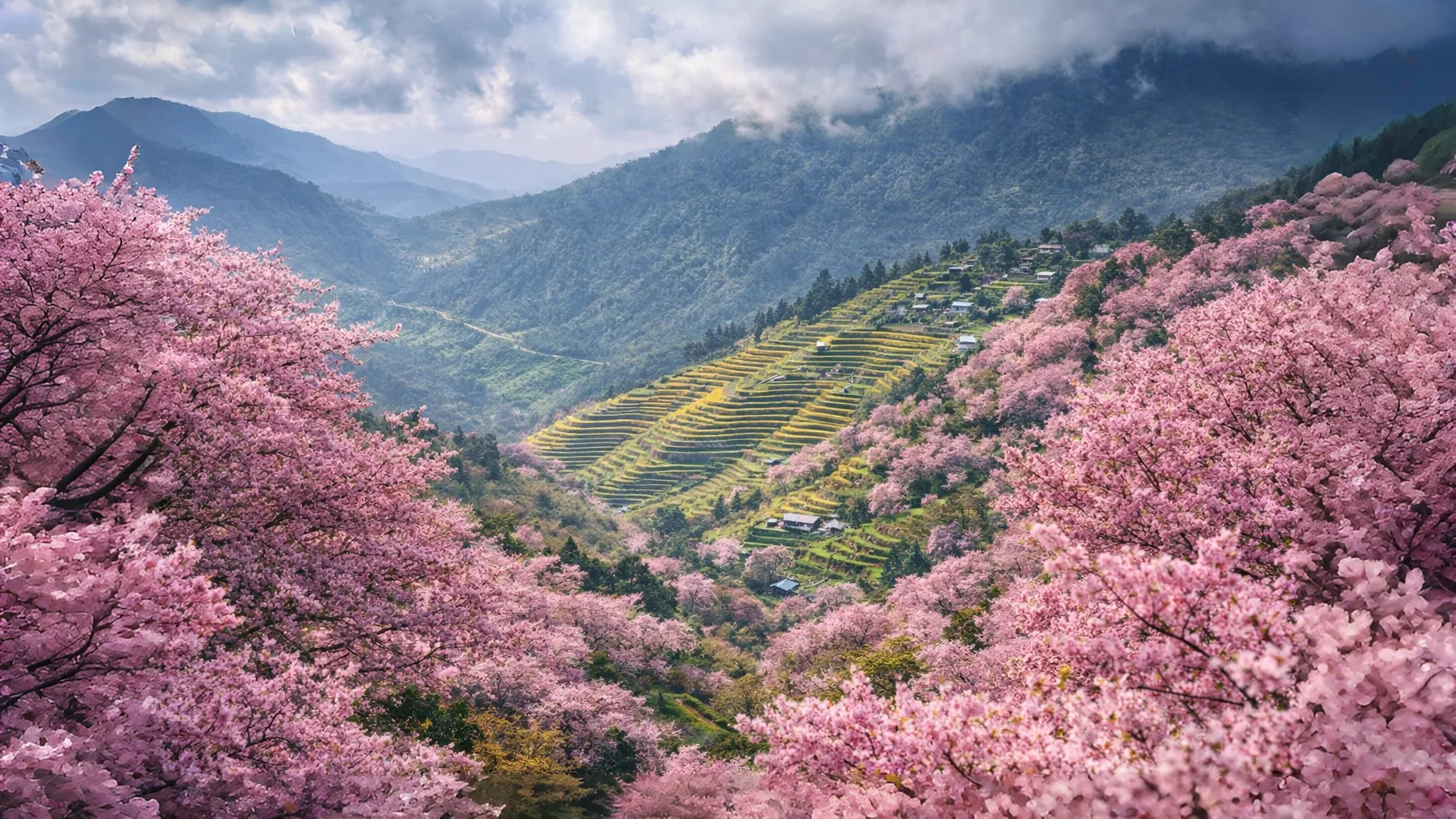
From mid‑November to early December, wild Himalayan cherry trees burst into bloom across the hillsides. The town and its surrounding trails turn pink — a spectacular seasonal phenomenon that draws photographers and nature lovers. Unlike the crowded cherry blossom festivals elsewhere, Pfutsero offers quiet, pristine views.
Switzerland of Nagaland Views
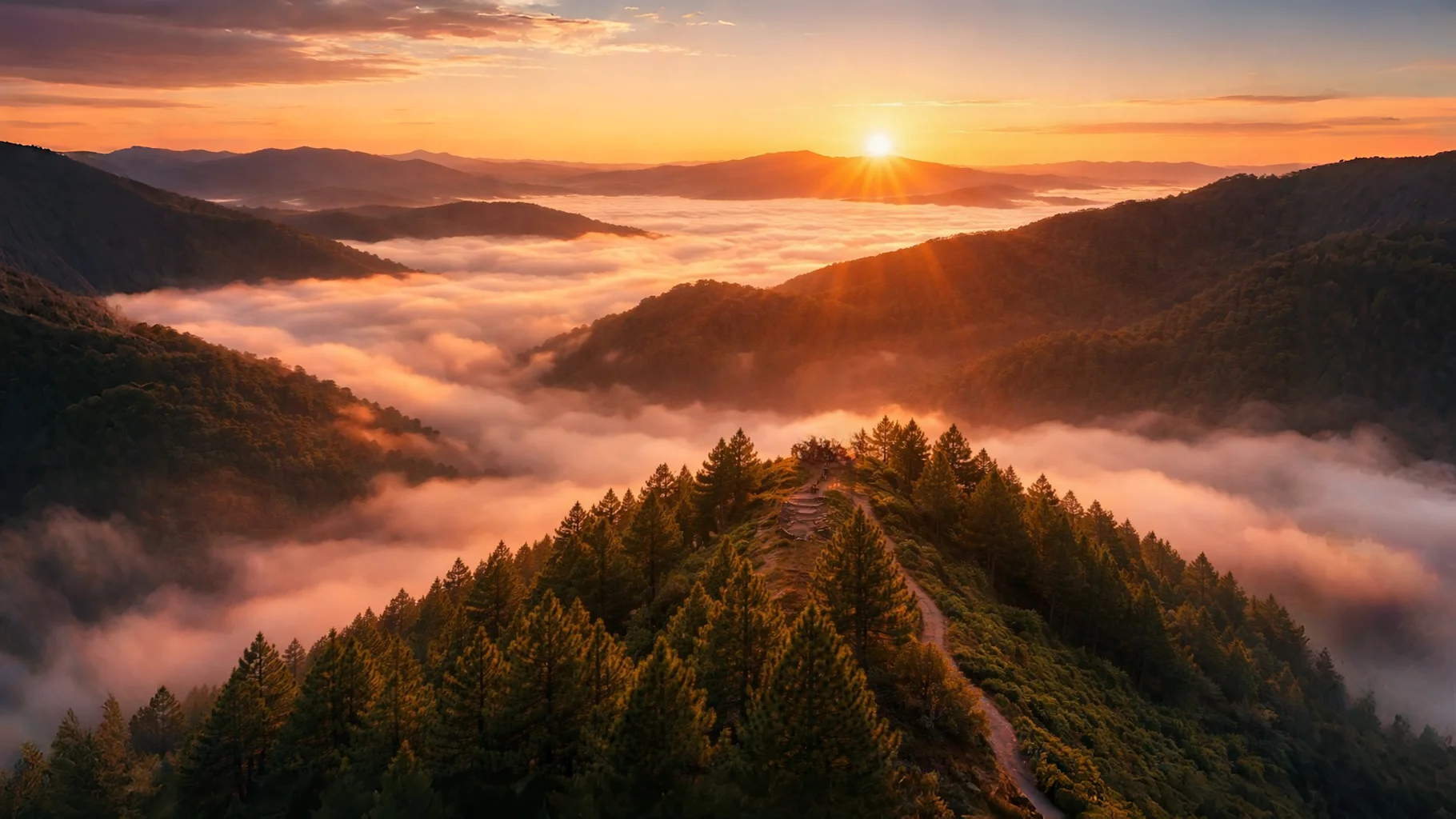
The rolling hills, pine forests, and terraced rice fields have earned Pfutsero the nickname “Switzerland of Nagaland”. At Glory Peak, the highest viewpoint near town, you get 360‑degree views of the Naga mountains, and on exceptionally clear days, even Mt. Everest is said to be visible.
Authentic Tribal Culture
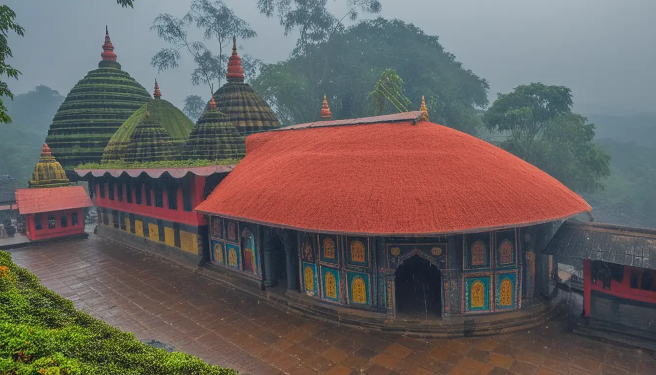
Pfutsero is the heartland of the Chakhesang Naga tribe — known for their warm hospitality, egalitarian values, and rich traditions. Unlike commercialized cultural centers, here you can experience village life, share meals with families, and if your timing is right, witness festivals like Tsükhenyie (late April) with its unique rituals of purification and feasting.
Permits: The Non‑Negotiable First Step
Unlike Tripura’s Montang Valley, Pfutsero requires permits. This is the single biggest difference between the two destinations.
For Indian Citizens: Inner Line Permit (ILP)
| Detail | Information |
|---|---|
| Where to apply | Online via the Nagaland eILP portal, or at Nagaland House in Delhi, Kolkata, Guwahati, Shillong, or at entry points like Dimapur |
| Validity | Typically 15 days (extendable in Kohima) |
| Documents needed | Aadhaar/Voter ID, recent passport‑size photo, live photo capture online |
| Cost | Varies by duration; standard tourist ILP ~₹300 for 15 days |
Critical: When applying, ensure you list Phek district specifically. A permit issued only for Kohima may not allow you to travel to Pfutsero.
For Foreign Nationals: Registration (No PAP Required Anymore)
| Detail | Information |
|---|---|
| Requirement | Foreign nationals no longer need a Restricted Area Permit (RAP) to visit most of Nagaland, including Pfutsero. However, they must register with the Foreigners Registration Office (FRO) in the district they are visiting within 24 hours of arrival. |
| Processing | Registration is straightforward; bring passport, visa, and hotel/homestay details. |
| Note | During the Hornbill Festival (December), requirements are often relaxed, but always check with the Ministry of Home Affairs before travel. |
⚠️ Important: If you’re a foreign national, do not arrive without having arranged registration. You will be assisted at the entry checkpost, but delays may occur.
Best Time to Visit Pfutsero
Pfutsero’s high‑altitude climate means each season offers a dramatically different experience.
| Season | Months | Temperature | Experience | Travel Suitability |
|---|---|---|---|---|
| Winter (Peak) | December–January | Sub‑zero nights, frost, 5–15°C days | Frozen fields, cherry blossoms (Nov–Dec), clear skies | Peak — stunning views, but pack warm |
| Spring | March–May | 10–20°C | Apple, peach, and plum blossoms; mild temperatures | Ideal for trekking and cultural festivals |
| Summer | May–June | 15–25°C | Pleasant weather, green landscapes | Good, but pre‑monsoon humidity starts |
| Monsoon | July–September | 15–25°C, heavy rain | Lush greenery, but landslides and road closures common | Avoid — significant travel risks |
| Autumn | October–November | 10–20°C, clear skies | Post‑monsoon clarity, ideal for photography | Excellent |
Seasonal Highlights
- Cherry blossoms: Mid‑November to early December — Pfutsero’s wild Himalayan cherry trees bloom, creating pink‑tinged landscapes. The best spots are the outskirts of town and the Tsupfume trail.
- Tsükhenyie Festival: Late April — the Chakhesang harvest festival, with folk dances, feasting, and community celebrations. It’s the most important cultural event in the Phek district.
- Aoleang: Another Chakhesang festival in April, though more prominent in western Nagaland.
How Many Days Do You Need in Pfutsero?
Most travelers visit Pfutsero as a 2–3 day trip from Kohima.
| Duration | Experience |
|---|---|
| 1 day | Possible but rushed. Depart Kohima early (7:00 AM), reach Pfutsero by late morning, visit Glory Peak for sunset, return same day. You’ll miss the slower village experiences. |
| 2 days | Ideal for covering the highlights: sunrise at Glory Peak, a short trek to Tsupfume or WWII caves, and a night in a local homestay. |
| 3 days | The perfect slow‑travel experience. Add a second village visit (Kikruma, Khezhakeno), a longer trek, or simply spend a day soaking in the quiet mountain atmosphere. |
If you’re combining with Dzukou Valley: Add 2–3 days for the trek.
How to Reach Pfutsero
Step 1: Reach Dimapur (Gateway to Nagaland)
| Mode | Details |
|---|---|
| By Air | Dimapur Airport (DMU) — flights from Kolkata, Delhi, Guwahati (~₹5,000–7,000) |
| By Train | Dimapur Railway Station — connected to Guwahati, Kolkata, Delhi |
| By Road | Buses from Guwahati to Dimapur (~6 hours) |
Step 2: Dimapur → Kohima (~70 km, 2–3 hours)
- Shared taxi: ₹150–200 per person from Dimapur’s taxi stand.
- Private taxi: ₹2,500–3,000 per vehicle.
Step 3: Kohima → Pfutsero (~70 km, 3–4 hours)
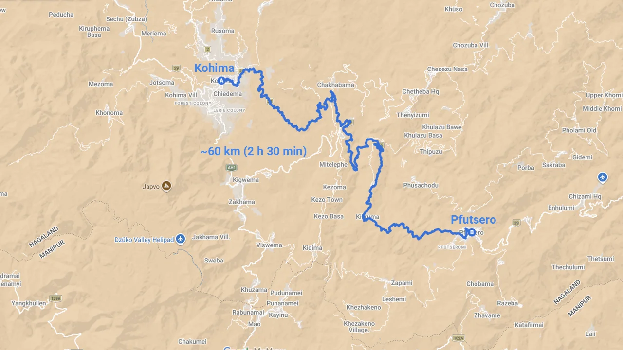
- Shared taxi: Departs from Kezekie taxi stand in Kohima. Depart by 7:00 AM — taxis fill early and leave as soon as they are full. Cost: ₹200–300 per person.
- Private taxi: ₹5,000–6,000 round trip (can be arranged with driver waiting).
- Morning bus: Limited services to Pfutsero (on route to Kiphire). Check at Kohima bus station.
Critical tip: For the return journey, the first shared taxi from Pfutsero to Kohima departs around 6:00 AM. Miss this window, and you may be stranded or forced to hire a private vehicle at a premium.
Road Conditions & Infrastructure
The historical isolation of Pfutsero was due to “appalling” road conditions. However, recent investments by the National Highways & Infrastructure Development Corporation (NHIDCL) have transformed connectivity:
- The new 62.56‑km two‑lane highway connecting Pfutsero to Phek town has reduced travel time from over 5 hours to about 2 hours.
- The Kohima–Jessami corridor (which includes the Pfutsero section) is under ongoing upgrade.
Despite improvements, the road remains winding and can be affected by landslides during monsoon. Avoid travel during heavy rain.
Where to Stay in Pfutsero
Accommodation in Pfutsero is basic but authentic. There are no luxury hotels — just community‑run lodges and homestays.
| Accommodation | Type | Details | Price (est.) |
|---|---|---|---|
| Mini Tourist Lodge (Wander Nagaland) | Lodge | On the outskirts with panoramic views; 8 bedrooms, 4 bathrooms; kitchen available. Book via Nagaland Tourism or local contacts. | ~₹800/night for double; meals ₹120–200 |
| Peak Lodge | Lodge | Centrally located; good base for sunrise hikes. | Check on arrival |
| Wander Nagaland Mini Tourist Homestay | Homestay | In town; friendly service, basic amenities. | ~₹800/night |
| Palm Guest House | Guesthouse | Appears on booking platforms; limited availability. | Variable |
| Lorin BnB | Guesthouse | Another limited‑availability option. | Variable |
| Glory Peak Campsite | Camping | At the summit; small hut, treetop sitting area, space for 10–15 tents. Bring your own gear. | Free or nominal fee |
| Tsupfume Village | Camping / Homestay | Flat meadow; no formal guesthouses. Ask locals for permission to camp. | Free or by arrangement |
Booking tips:
- Call the Phek District Tourism Office or Wander Nagaland directly for current availability.
- During winter (Dec–Feb) and festival seasons, accommodations fill quickly. Book at least 2 weeks in advance.
- Homestays often have no online presence — arrange through local contacts or ask in Kohima before traveling.
Because online booking options are limited, most travelers arrange stays through Nagaland Tourism, Wander Nagaland, or contacts in Kohima. If you prefer easier logistics, many travelers choose to stay in Kohima and visit Pfutsero as a day trip or overnight excursion.
Top Attractions & Activities
1. Glory Peak (Zhuketsu Peak) — The Sunrise Viewpoint
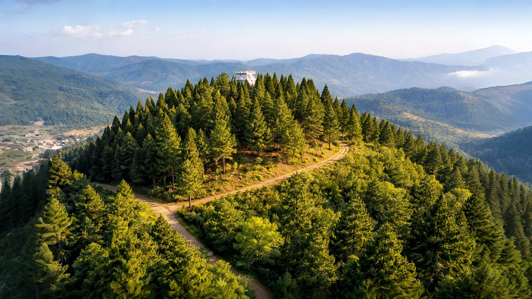
| Detail | Information |
|---|---|
| Location | ~4 km from Pfutsero town centre |
| Altitude | Over 2,100 m |
| Best time | Sunrise (arrive by 5:00 AM) |
| Entry fee | Free |
| Hike duration | 20–30 minutes gentle walk, or drive up |
| What to expect | 360‑degree views of the valley, floating clouds, Mt. Saramati, and on exceptionally clear days, even Mt. Everest is said to be visible. |
Facilities: A viewpoint tower, a small hut, a treetop sitting area, and a campsite for 10–15 people. Camping is often free — bring your own tent and sub‑zero sleeping gear.
Traveler’s note: “I remember my first sunrise at Pfutsero. As the golden rays kissed the rolling hills, I stood mesmerized by the tranquility, sipping local tea with a Chakhesang family who welcomed me like their own.”
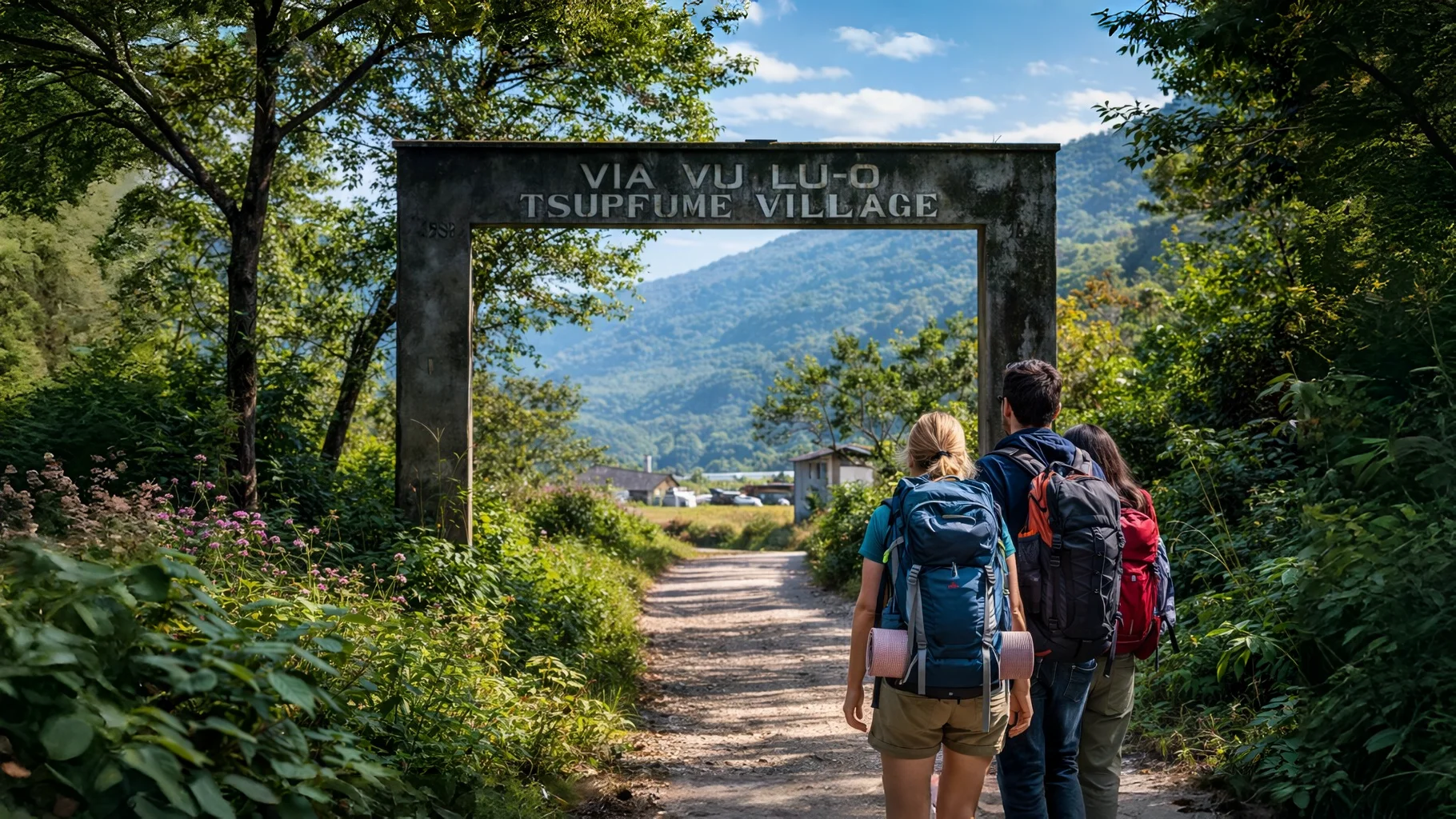
2. Tsupfume Trek — The Vegetable Village
| Detail | Information |
|---|---|
| Location | ~7 km south of Pfutsero |
| Access | 3‑hour walk (or jeep ride, hire ~₹400–800) through terraced fields and wild cherry trees |
| What to expect | Rice fields, flowers, cherry blossoms; famous for ground apples (yacon). The village is less accustomed to tourists — be respectful. |
| Accommodation | No formal guesthouses. Camping is possible in meadows (ask locals first). |
Insider tip: The walk is beautiful, but be prepared for the possibility that villagers may be surprised to see you. A local guide from Pfutsero can ease interactions.
3. WWII Japanese Cave
| Detail | Information |
|---|---|
| Location | ~3 km outside Pfutsero |
| What to expect | Caves used as refuge by Japanese soldiers during their retreat in World War II. A sobering historical site. |
4. Shilloi Lake
| Detail | Information |
|---|---|
| Location | ~30 km from Pfutsero |
| Entry fee | ~₹50 (estimated 2026) |
| Best time | September–March |
| What to expect | Scenic lake surrounded by myths and greenery; pack snacks — facilities are minimal. |
5. Khezhakeno — The Cradle of Naga Migration
| Detail | Information |
|---|---|
| Location | ~25 km from Pfutsero (on the way to Kohima) |
| What to expect | A historic village believed to be the ancestral home from which many Naga tribes migrated. Visit Tso Tawo, a flat stone believed to double the yield of any basket of paddy placed upon it. |
6. Chida Lake & Other Lakes
- Chida Lake: A tranquil body of water on the Nagaland‑Manipur border, often shrouded in mist — a “fairy tale” atmosphere.
- Zanibu Lake: Another serene high‑altitude lake surrounded by pine forests.
7. Pfutsero Local Market
- Location: Central Pfutsero.
- Best for: Handwoven Chakhesang shawls (look for GI‑tagged products), bamboo crafts, fresh organic produce, axone (fermented soybean), and local snacks.
- Tip: Bargain politely — it’s part of the culture.
Sample Itineraries
2‑Day Quick Escape (From Kohima)
| Day | Activities |
|---|---|
| Day 1 | 7:00 AM — Shared taxi from Kohima to Pfutsero (~3–4 hours). Check in at Tourist Lodge. Afternoon hike to Glory Peak for sunset. Overnight in Pfutsero. |
| Day 2 | 5:00 AM — Sunrise at Glory Peak. Return for breakfast. Visit local market, then depart for Kohima (shared taxi by 11:00 AM). |
3‑Day Cultural Immersion
| Day | Activities |
|---|---|
| Day 1 | Arrive Pfutsero. Check in. Visit Pfutsero Baptist Church, local market. Evening with homestay family — try thuthse. |
| Day 2 | 5:00 AM — Glory Peak sunrise. Return for breakfast. Afternoon trek to Tsupfume (or drive). Explore vegetable village, meet locals. Overnight at Pfutsero. |
| Day 3 | Morning walk to WWII Japanese Cave or Chida Lake. Depart for Kohima by early afternoon. |
Extended Circuit: Nagaland’s Wild Heart (8–10 Days)
| Stop | Activities |
|---|---|
| Dimapur → Kohima | Kohima War Cemetery, local markets |
| Kohima → Pfutsero | Glory Peak, Tsupfume, WWII caves, Shilloi Lake |
| Pfutsero → Dzukou Valley | Iconic trek (requires 4×4 vehicle) |
| Dzukou → Dimapur | Return |
Local Food & Drinks: The Flavors of the Highlands
Pfutsero’s food culture is deeply tied to terrace rice cultivation and the art of fermentation.
Signature Ingredients
| Ingredient | Description |
|---|---|
| Axone (Akhuni) | Fermented soybean, the most ubiquitous ingredient. Prepared by boiling soybeans, wrapping them in banana leaves, and placing them near a kitchen fire for several days. Pungent and smoky — an acquired taste. |
| Anishi | Fermented and smoked yam leaves, made into patties. Cooked with pork, it creates a dark, earthy gravy. |
| Fermented bamboo shoot (Bastenga) | Used fresh or dried to add a tangy, sour flavor to fish and meat dishes. |
| Local sticky rice | The staple grain, often eaten with meat and vegetable stews. |
Must‑Try Dishes
| Dish | Type | Description |
|---|---|---|
| Galho | Main dish | A traditional Naga “khichdi” made by boiling rice, vegetables, and meat (often smoked pork) into a thick, porridge‑like consistency. Perfect for cold winter mornings. |
| Smoked pork with axone | Main dish | The signature Chakhesang dish — smoky, pungent, and deeply satisfying. |
| Anishi with pork | Main dish | Earthy, dark gravy with tender pork. |
| Tathu | Condiment | A fiery chili chutney made with local Naga peppers. |
| Hamuk | Snack | Edible snails harvested from rice fields — a seasonal delicacy. |
Beverages
| Beverage | Description |
|---|---|
| Zutho | The common rice beer across Nagaland — mildly alcoholic, slightly sour, and served at room temperature. |
| Thuthse | A thicker, stronger, and sweeter variant favored by the Chakhesang, often reserved for special occasions. |
Where to eat: Most homestays and the Tourist Lodge serve fresh, home‑cooked meals. The local market has snacks and axone products. Vegetarians should ask for galho and boiled vegetables — meat is dominant.
Cultural Etiquette: Navigating the Chakhesang Way
The Chakhesang tribe is known for its “warmest hospitality” and a strong sense of egalitarianism and honor. Understanding a few cultural norms will make your visit deeply rewarding.
The Concept of “Shame”
Naga culture is built upon the sovereign equality of individuals, clans, and villages. There is no caste hierarchy; status is earned through “feasts of merit” and personal integrity.
A core concept is the “sense of shame” associated with transgressing social norms. In business transactions, it is considered deeply shameful to sell a commodity at a price higher than its true value. This ethical framework ensures a high degree of safety for travelers, as opportunistic overcharging is culturally stigmatized.
Chakhesang Attire Regulatory Board (CARB)
Traditional Naga attire is viewed as an “autobiography” of the wearer’s life journey, status, and achievements. The CARB strictly protects these garments.
| Do | Don’t |
|---|---|
| Ask permission before photographing anyone in traditional dress, especially during festivals. | Wear sacred motifs or ornaments unless their meaning is fully understood. |
| Purchase shawls from authorized weavers or NGO‑run shops (look for GI‑542 tag). | Buy “replica” shawls that appropriate cultural patterns without context. |
| If invited to wear a traditional shawl for a photo, accept the offer gratefully. | Use traditional attire as a costume for “exotic” photos. |
General Etiquette
| Do | Don’t |
|---|---|
| Accept hospitality — tea, rice beer, meals — with gratitude. | Refuse abruptly; it’s considered rude. |
| Dress modestly, especially in villages. | Wear revealing clothing in public. |
| Respect quiet village life — no loud music after dark. | Expect nightlife or party scenes. |
| Ask before entering homes or taking photos of interiors. | Assume entry or photography is welcome. |
Festivals: Observing Without Interfering
The Tsükhenyie festival (late April) is the most important cultural event. A central ritual involves men visiting the local spring at dawn to wash themselves, their tools, and their weapons — a purification for the new agricultural cycle.
During the festival, a unique ritual involves the “cock throttling” ceremony, where men of appropriate age must kill an unblemished cock using only their hands. This is followed by days of feasting, communal dancing, and singing.
For travelers: Witnessing these rituals requires a “slow traveler” mindset — observe quietly, do not interrupt, and follow the lead of your host or local guide.
Practical Tips for the High‑Altitude Traveler
Health & Emergency
- Medical facilities: Pfutsero has a Senior Medical Office (SMO) for basic care. For serious emergencies, you’ll need to go to Kohima (3–4 hours) or Dimapur.
- Emergency contact: Directorate of Health & Family Welfare, Kohima: 0370‑2270459.
- Altitude: At 2,133 m, mild altitude symptoms (headache, shortness of breath) can occur, especially if you arrive from sea level. Stay hydrated, avoid alcohol for the first day, and take it slow.
Cash & Connectivity
- Cash: Pfutsero is a cash‑based economy. There are 1–2 ATMs in town, but they frequently run out of cash or experience technical failures. Withdraw sufficient cash in Kohima.
- Mobile networks: Airtel and Jio have coverage in town, but data speeds are intermittent. BSNL works in some areas. Do not rely on high‑speed internet for navigation or work.
- Sunday Protocol: Nagaland observes Sunday as a day of rest. Shared taxis do not ply, and most shops and eateries are closed. Plan arrivals/departures Monday–Saturday.
Packing for Sub‑Zero Conditions
- Layering: Moisture‑wicking base layer, fleece mid‑layer, windproof/waterproof down jacket.
- Extremities: Woolen beanie, neck gaiter, warm gloves, thick socks.
- Footwear: Sturdy, broken‑in trekking shoes with good grip.
- Hydration: Water can freeze in bladders. Use an insulated Nalgene bottle or wrap your water bottle in an old wool sock.
- Power: Carry a 20,000 mAh power bank — load‑shedding can occur.
Environment & Safety
- Wildlife: The forests are home to wild elephants and other animals. Stay on marked trails and ask locals about recent sightings.
- Leave No Trace: Carry out all trash. There is no formal garbage collection in remote areas.
- Road safety: Avoid travel during monsoon (June–September) due to landslide risk. On mountain roads, drive slowly and honk around blind turns.
Who Should Visit Pfutsero Highlands?
Pfutsero is not a typical tourist destination — and that’s exactly its charm.
This destination is perfect for:
- Travelers who love offbeat mountain towns — no crowds, no commercialization, just quiet trails and pine forests
- Photographers chasing mist, frost, and sunrise views — Glory Peak offers some of the most dramatic morning light in Nagaland
- Cultural explorers interested in tribal heritage — Chakhesang villages welcome respectful travelers with genuine hospitality
- Repeat Northeast India visitors ready to go deeper — if you’ve already done Meghalaya, Tawang, and Dzukou Valley, Pfutsero is the next layer
If Tripura’s Montang Valley is the easy cloud‑view destination, Pfutsero is the raw, high‑altitude adventure. One is a weekend trip; the other is a journey that rewards patience with silence, frost, and the warmth of a community that still lives by its own ancient rhythms.
If that sounds like you, Pfutsero is waiting.
FAQ: Pfutsero Travel Guide
Is Pfutsero the same as Montang Valley?
No. Pfutsero is the official name of Nagaland’s highest town. Travelers informally use “Montang” for its cloud‑viewpoints due to visual similarity to Tripura’s Montang Valley.
Do I need a permit to visit Pfutsero?
Yes — Indian citizens need an Inner Line Permit (ILP) for Nagaland. Foreign nationals must register with the FRO within 24 hours of arrival.
What is the best time to see cherry blossoms?
Mid‑November to early December. The wild Himalayan cherry trees bloom, turning hillsides pink.
Is a personal Pfutsero travel guide available?
While there is no dedicated “Pfutsero Travel Guide Association,” several options exist for hiring a personal or local guide for your trip:
– Government-Approved Tour Operators
– Licensed Independent Guides
– Experienced Driver-Guides
– Informal Local Assistance
-Community-Led Pfutsero travel guide
Is Pfutsero safe for solo travelers?
Yes. Nagaland is generally safe, and the Chakhesang people are known for hospitality. However, road travel and remote areas require standard precautions. See our Solo Female Travel Safety Guide for Northeast India for more.
What is there to eat for vegetarians?
Meat is central to Naga cuisine, but you can request galho(rice porridge with vegetables), boiled local greens, and tathu chili chutney. Homestays will accommodate dietary restrictions if you inform them in advance.
Can I camp at Glory Peak?
Yes. There is a campsite at the summit with space for 10–15 tents. Facilities are minimal — bring your own gear. Camping is often free.
How do I book a homestay in Pfutsero?
Pfutsero Homestays have limited online presence. Contact the Phek District Tourism Office or Wander Nagaland directly. Alternatively, ask at the Tourist Lodge upon arrival — they can often arrange nearby homestays.
Pfutsero vs Tripura’s Montang Valley: Quick Comparison
| Factor | Pfutsero, Nagaland | Montang Valley, Tripura |
|---|---|---|
| Official name | Pfutsero | Montang Valley |
| Elevation | 2,133–2,136 m | ~300–500 m |
| Climate | Temperate highland; sub‑zero winters | Humid subtropical; mild winters |
| Permit required | Yes — ILP for Indians, registration for foreigners | No |
| Travel difficulty | High — permits, winding roads | Moderate — doable weekend trip |
| Culture | Chakhesang Naga | Tripuri (Kokborok) |
| Best season | October–March (cherry blossoms Nov–Dec) | October–March (clear skies) |
| Infrastructure | Basic lodges, homestays, camping | Basic shops, one makeshift restaurant |
| Best for | Serious explorers, cultural immersion | Accessible cloud‑view destination |
What’s Next in the Montang Cluster
| Article | Purpose |
|---|---|
| Montang Valley: Tripura or Nagaland? | Clarify the naming confusion – start here if you’re new |
| Montang Valley Tripura Travel Guide | For the accessible cloud‑view destination |
| How to Reach Montang Valley | Logistics for Tripura |
| Montang Valley Homestays | Accommodation near Tripura’s Montang |
| You are here: Pfutsero Travel Guide | The advanced Nagaland experience |
Explore deeper into Northeast India:
- Kamakhya to Kohima: A Cultural Journey — another iconic Northeast route
- Hidden paradise, Ziro Valley Travel Guide — more offbeat destinations
- Solo Female Travel Safety Guide for Northeast India — essential reading for all travelers
Last updated: March 2026. Permit rules, road conditions, and accommodation availability change. Always verify ILP requirements and road status with Nagaland Tourism before travel.
Found this Pfutsero travel guide helpful? Share it with someone planning a serious Northeast India adventure — and tag us in your Glory Peak sunrise photos.